Velden night lights from space
Night Light of Velden (Bavaria) from space (Germany) Src. Average luminocity for 10x10km area is 0.6364% and for 50x50km: 3.402%.
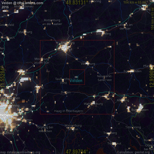
Analysis of Velden night lights 2016
Square area 10x10 km:
 0%
0%90-99
0%80-89
0%70-79
0%60-69
0%50-59
0%40-49
0.57%30-39
1.14%20-29
0%10-19
0%0-9
98.3%Square area 50x50 km:
0.42%90-99
0.59%80-89
0.31%70-79
0.39%60-69
0.42%50-59
0.35%40-49
0.5%30-39
0.5%20-29
0.81%10-19
2.04%0-9
93.66%Clear (daylight) street map image can be seen on geolist.org.
Map coordinates:
48° 49' 52.7" North, 11° 33' 10.2" East
48° 21' 58.8" North, 12° 15' 21.5" East
47° 53' 49.3" North, 12° 57' 32.7" East
Some cities around Velden sort by population:
• Landshut
19.4 km =12.1 mi,  339°
339°
• Dorfen
12.8 km =8 mi,  213°
213°
• Vilsbiburg
12.1 km =7.5 mi,  37°
37°
• Taufkirchen
9.3 km =5.8 mi,  258°
258°
• Geisenhausen
12.2 km =7.6 mi,  0°
0°
• Neumarkt-Sankt Veit
18.6 km =11.6 mi,  91°
91°
• Ampfing
17.2 km =10.7 mi,  136°
136°
• Bodenkirchen
9.6 km =6 mi,  78°
78°
2817719 (p: 6,488)
Sources (retrieved 2019-11-25):
» Earth at Night: Flat Maps 2012, 2016