Dorfen night lights from space
Night Light of Dorfen (Bavaria) from space (Germany) Src. Average luminocity for 10x10km area is 1.5685% and for 50x50km: 2.4004%.
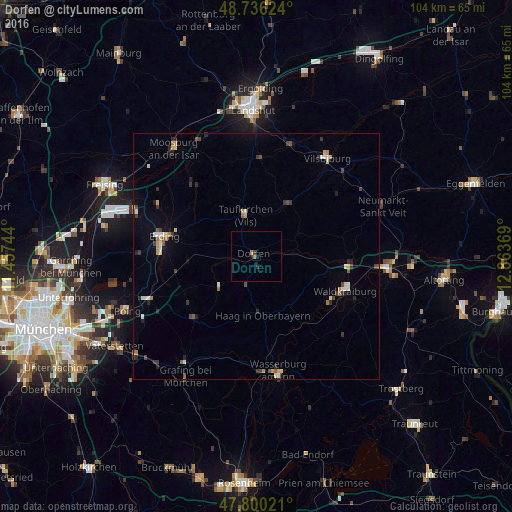
Analysis of Dorfen night lights 2016
Square area 10x10 km:
 0%
0%90-99
0%80-89
0%70-79
0%60-69
1.19%50-59
0%40-49
0.3%30-39
0.3%20-29
0.6%10-19
1.19%0-9
96.43%Square area 50x50 km:
0.2%90-99
0.33%80-89
0.28%70-79
0.27%60-69
0.31%50-59
0.22%40-49
0.41%30-39
0.53%20-29
0.52%10-19
0.52%0-9
96.41%Clear (daylight) street map image can be seen on geolist.org.
Map coordinates:
48° 44' 10.5" North, 11° 27' 26.8" East
48° 16' 13.3" North, 12° 9' 38" East
47° 48' 0.8" North, 12° 51' 49.3" East
Some cities around Dorfen sort by population:
• Erding
19.2 km =11.9 mi,  281°
281°
• Waldkraiburg
18.9 km =11.7 mi,  111°
111°
• Altdorf
13.1 km =8.1 mi,  172°
172°
• Taufkirchen
9.1 km =5.7 mi,  346°
346°
• Velden
12.8 km =8 mi,  33°
33°
• Haag in Oberbayern
12.1 km =7.5 mi, 173°
• Ampfing
18.9 km =11.7 mi,  95°
95°
• Isen
10.1 km =6.3 mi,  229°
229°
2936103 (p: 13,487)
Sources (retrieved 2019-11-25):
» Earth at Night: Flat Maps 2012, 2016