Neumarkt-Sankt Veit night lights from space
Night Light of Neumarkt-Sankt Veit (Bavaria) from space (Germany) Src. Average luminocity for 10x10km area is 0.6506% and for 50x50km: 3.4075%.
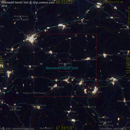
Analysis of Neumarkt-Sankt Veit night lights 2016
Square area 10x10 km:
 0%
0%90-99
0%80-89
0%70-79
0%60-69
0%50-59
0%40-49
0.71%30-39
0.43%20-29
0.57%10-19
0%0-9
98.3%Square area 50x50 km:
0.39%90-99
0.49%80-89
0.32%70-79
0.42%60-69
0.39%50-59
0.4%40-49
0.64%30-39
0.5%20-29
0.54%10-19
1.45%0-9
94.46%Clear (daylight) street map image can be seen on geolist.org.
Map coordinates:
48° 49' 32" North, 11° 48' 14.8" East
48° 21' 37.8" North, 12° 30' 26" East
47° 53' 28.2" North, 13° 12' 37.3" East
Some cities around Neumarkt-Sankt Veit sort by population:
• Mühldorf
12.7 km =7.9 mi,  175°
175°
• Vilsbiburg
15.2 km =9.4 mi,  312°
312°
• Töging am Inn
12.5 km =7.8 mi,  152°
152°
• Gangkofen
9.5 km =5.9 mi,  26°
26°
• Velden
18.6 km =11.6 mi,  271°
271°
• Ampfing
13.7 km =8.5 mi,  209°
209°
• Rohrbach
8.7 km =5.4 mi,  155°
155°
• Bodenkirchen
9.5 km =5.9 mi,  285°
285°
2864547 (p: 6,231)
Sources (retrieved 2019-11-25):
» Earth at Night: Flat Maps 2012, 2016