Großbottwar night lights from space
Night Light of Großbottwar (Baden-Württemberg) from space (Germany) Src. Average luminocity for 10x10km area is 12.4821% and for 50x50km: 19.5261%.
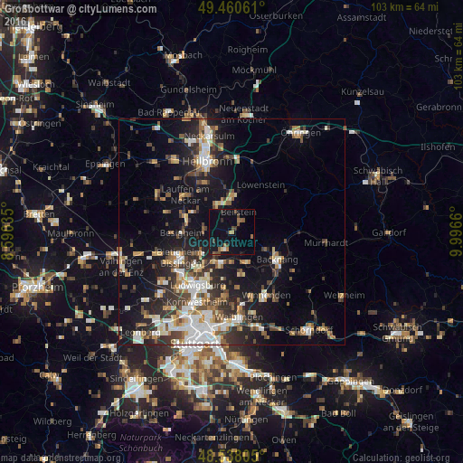
Analysis of Großbottwar night lights 2016
Square area 10x10 km:
 0%
0%90-99
0.6%80-89
0.6%70-79
1.19%60-69
2.38%50-59
2.53%40-49
2.53%30-39
2.08%20-29
1.79%10-19
10.12%0-9
76.19%Square area 50x50 km:
3.23%90-99
3.48%80-89
1.67%70-79
2.2%60-69
2.47%50-59
2.59%40-49
2.84%30-39
3.14%20-29
5.53%10-19
12.42%0-9
60.43%Clear (daylight) street map image can be seen on geolist.org.
Map coordinates:
49° 27' 38.2" North, 8° 35' 25.3" East
49° 0' 5.3" North, 9° 17' 36.5" East
48° 32' 17" North, 9° 59' 47.8" East
Some cities around Großbottwar sort by population:
• Marbach am Neckar
7.3 km =4.5 mi,  199°
199°
• Steinheim am der Murr
3.9 km =2.4 mi, 197°
• Ilsfeld
6.9 km =4.3 mi,  330°
330°
• Oberstenfeld
3.4 km =2.1 mi,  36°
36°
• Pleidelsheim
8.1 km =5 mi,  234°
234°
• Beilstein
4.7 km =2.9 mi,  18°
18°
• Murr
5 km =3.1 mi,  209°
209°
• Benningen am Neckar
7.1 km =4.4 mi, 211°
2916936 (p: 8,294)
Sources (retrieved 2019-11-25):
» Earth at Night: Flat Maps 2012, 2016