Beilstein night lights from space
Night Light of Beilstein (Baden-Württemberg) from space (Germany) Src. Average luminocity for 10x10km area is 13.9598% and for 50x50km: 16.0519%.
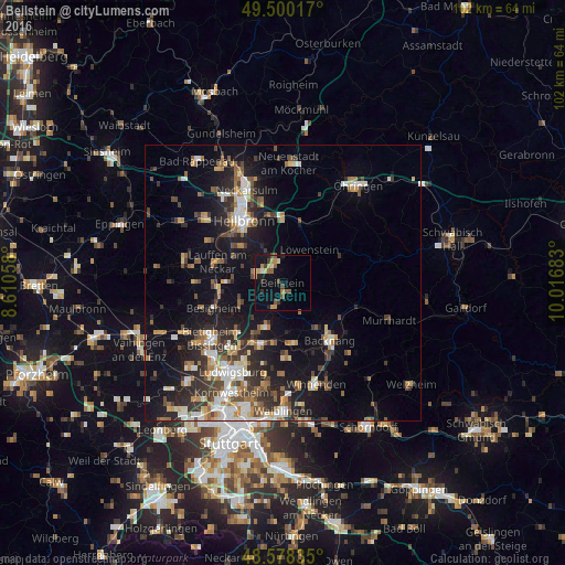
Analysis of Beilstein night lights 2016
Square area 10x10 km:
 0.3%
0.3%90-99
0.89%80-89
1.93%70-79
3.42%60-69
1.19%50-59
3.72%40-49
2.38%30-39
1.93%20-29
1.64%10-19
7.29%0-9
75.3%Square area 50x50 km:
2.14%90-99
2.46%80-89
1.47%70-79
1.86%60-69
2.23%50-59
2.27%40-49
2.35%30-39
2.73%20-29
4.74%10-19
11.63%0-9
66.13%Clear (daylight) street map image can be seen on geolist.org.
Map coordinates:
49° 30' 0.6" North, 8° 36' 38.1" East
49° 2' 29" North, 9° 18' 49.3" East
48° 34' 42.1" North, 10° 1' 0.6" East
Some cities around Beilstein sort by population:
• Steinheim am der Murr
8.6 km =5.3 mi,  198°
198°
• Großbottwar
4.7 km =2.9 mi, 198°
• Ilsfeld
5.2 km =3.2 mi,  287°
287°
• Aspach
10.4 km =6.5 mi,  142°
142°
• Oberstenfeld
1.8 km =1.1 mi,  163°
163°
• Untergruppenbach
6 km =3.7 mi,  332°
332°
• Flein
10.2 km =6.3 mi,  312°
312°
• Murr
9.7 km =6 mi, 204°
2951346 (p: 6,103)
Sources (retrieved 2019-11-25):
» Earth at Night: Flat Maps 2012, 2016