Zeitlarn night lights from space
Night Light of Zeitlarn (Bavaria) from space (Germany) Src. Average luminocity for 10x10km area is 17.4482% and for 50x50km: 5.0554%.
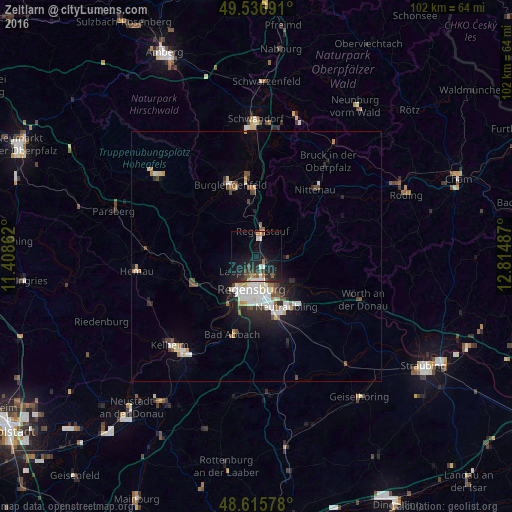
Analysis of Zeitlarn night lights 2016
Square area 10x10 km:
 1.68%
1.68%90-99
2.52%80-89
0%70-79
0.98%60-69
2.94%50-59
2.24%40-49
1.68%30-39
2.66%20-29
9.94%10-19
25.77%0-9
49.58%Square area 50x50 km:
0.92%90-99
1.08%80-89
0.35%70-79
0.46%60-69
0.42%50-59
0.52%40-49
0.79%30-39
0.36%20-29
1.52%10-19
3.11%0-9
90.48%Clear (daylight) street map image can be seen on geolist.org.
Map coordinates:
49° 32' 12.9" North, 11° 24' 31" East
49° 4' 42.5" North, 12° 6' 42.3" East
48° 36' 56.8" North, 12° 48' 53.5" East
Some cities around Zeitlarn sort by population:
• Regensburg
7.1 km =4.4 mi,  185°
185°
• Regenstauf
4.8 km =3 mi,  16°
16°
• Lappersdorf
3.8 km =2.4 mi,  203°
203°
• Reinhausen
5.3 km =3.3 mi,  178°
178°
• Wenzenbach
6.4 km =4 mi,  92°
92°
• Sinzing
10.4 km =6.5 mi,  213°
213°
• Bernhardswald
10 km =6.2 mi,  81°
81°
• Pentling
11.3 km =7 mi, 200°
2804933 (p: 5,849)
Sources (retrieved 2019-11-25):
» Earth at Night: Flat Maps 2012, 2016