Nittenau night lights from space
Night Light of Nittenau (Bavaria) from space (Germany) Src. Average luminocity for 10x10km area is 1.4398% and for 50x50km: 4.6166%.
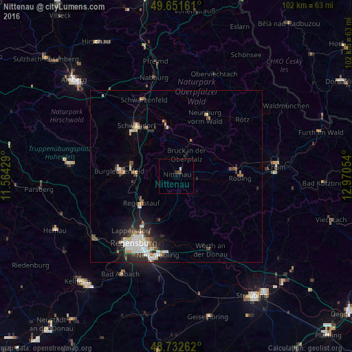
Analysis of Nittenau night lights 2016
Square area 10x10 km:
 0.28%
0.28%90-99
0.28%80-89
0%70-79
0%60-69
0%50-59
0%40-49
1.12%30-39
0.28%20-29
0.28%10-19
0%0-9
97.76%Square area 50x50 km:
0.88%90-99
1.01%80-89
0.32%70-79
0.4%60-69
0.45%50-59
0.54%40-49
0.74%30-39
0.44%20-29
1.46%10-19
2.19%0-9
91.57%Clear (daylight) street map image can be seen on geolist.org.
Map coordinates:
49° 39' 5.8" North, 11° 33' 51.4" East
49° 11' 39.3" North, 12° 16' 2.7" East
48° 43' 57.4" North, 12° 58' 13.9" East
Some cities around Nittenau sort by population:
• Regenstauf
12.9 km =8 mi,  230°
230°
• Burglengenfeld
16.2 km =10.1 mi,  273°
273°
• Roding
18.3 km =11.4 mi,  89°
89°
• Maxhütte-Haidhof
12.7 km =7.9 mi, 272°
• Wenzenbach
14.1 km =8.8 mi,  200°
200°
• Teublitz
13.5 km =8.4 mi,  283°
283°
• Zeitlarn
17.1 km =10.6 mi,  221°
221°
• Bernhardswald
11.5 km =7.1 mi,  187°
187°
2862348 (p: 8,478)
Sources (retrieved 2019-11-25):
» Earth at Night: Flat Maps 2012, 2016