Simbach am Inn night lights from space
Night Light of Simbach am Inn (Bavaria) from space (Germany) Src. Average luminocity for 10x10km area is 15.3988% and for 50x50km: 3.1356%.
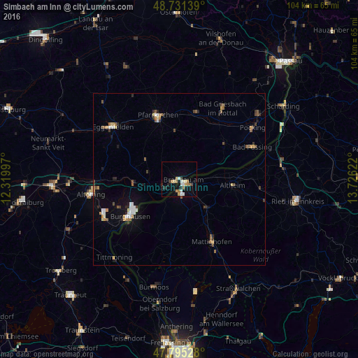
Analysis of Simbach am Inn night lights 2016
Square area 10x10 km:
 1.79%
1.79%90-99
2.98%80-89
1.64%70-79
2.53%60-69
3.27%50-59
0.3%40-49
0.74%30-39
1.34%20-29
2.38%10-19
8.78%0-9
74.26%Square area 50x50 km:
0.39%90-99
0.42%80-89
0.23%70-79
0.46%60-69
0.43%50-59
0.49%40-49
0.34%30-39
0.44%20-29
0.46%10-19
1.42%0-9
94.93%Clear (daylight) street map image can be seen on geolist.org.
Map coordinates:
48° 43' 53" North, 12° 19' 11.9" East
48° 15' 55.7" North, 13° 1' 23.1" East
47° 47' 43" North, 13° 43' 34.4" East
Some cities around Simbach am Inn sort by population:
• Burghausen
17.8 km =11.1 mi,  233°
233°
• Pfarrkirchen
19.6 km =12.2 mi,  341°
341°
• Bad Füssing
23.4 km =14.5 mi,  66°
66°
• Mattighofen, AT
20 km =12.4 mi,  151°
151°
• Bad Birnbach
20.6 km =12.8 mi,  14°
14°
• Triftern
14.4 km =8.9 mi,  355°
355°
• Kirchdorf am Inn
3.5 km =2.2 mi,  235°
235°
• Rotthalmünster
16.8 km =10.4 mi,  51°
51°
2832043 (p: 9,979)
Sources (retrieved 2019-11-25):
» Earth at Night: Flat Maps 2012, 2016