Bad Füssing night lights from space
Night Light of Bad Füssing (Bavaria) from space (Germany) Src. Average luminocity for 10x10km area is 2.6761% and for 50x50km: 2.2415%.
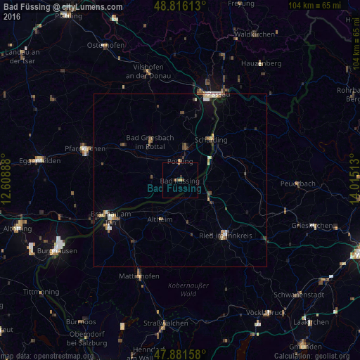
Analysis of Bad Füssing night lights 2016
Square area 10x10 km:
 0%
0%90-99
0%80-89
0%70-79
1.14%60-69
0.43%50-59
0.99%40-49
0.57%30-39
0.85%20-29
0%10-19
0%0-9
96.02%Square area 50x50 km:
0.21%90-99
0.3%80-89
0.29%70-79
0.27%60-69
0.29%50-59
0.27%40-49
0.41%30-39
0.42%20-29
0.3%10-19
1.02%0-9
96.21%Clear (daylight) street map image can be seen on geolist.org.
Map coordinates:
48° 48' 58.1" North, 12° 36' 32" East
48° 21' 3.6" North, 13° 18' 43.2" East
47° 52' 53.7" North, 14° 0' 54.5" East
Some cities around Bad Füssing sort by population:
• Pocking
5.6 km =3.5 mi,  0°
0°
• Ried im Innkreis, AT
20.3 km =12.6 mi,  139°
139°
• Bad Griesbach
14.2 km =8.8 mi,  321°
321°
• Fürstenzell
19 km =11.8 mi, 1°
• Ortenburg
22.7 km =14.1 mi,  343°
343°
• Bad Birnbach
19.4 km =12.1 mi,  302°
302°
• Triftern
23.1 km =14.4 mi,  282°
282°
• Rotthalmünster
8.2 km =5.1 mi, 275°
2923500 (p: 6,701)
Sources (retrieved 2019-11-25):
» Earth at Night: Flat Maps 2012, 2016