Burghausen night lights from space
Night Light of Burghausen (Bavaria) from space (Germany) Src. Average luminocity for 10x10km area is 19.7664% and for 50x50km: 3.6931%.
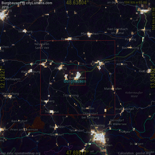
Analysis of Burghausen night lights 2016
Square area 10x10 km:
 4.91%
4.91%90-99
4.61%80-89
0.3%70-79
2.08%60-69
1.79%50-59
0.6%40-49
1.49%30-39
0.74%20-29
2.83%10-19
20.39%0-9
60.27%Square area 50x50 km:
0.42%90-99
0.63%80-89
0.37%70-79
0.46%60-69
0.47%50-59
0.38%40-49
0.48%30-39
0.32%20-29
0.51%10-19
1.61%0-9
94.35%Clear (daylight) street map image can be seen on geolist.org.
Map coordinates:
48° 38' 9.7" North, 12° 7' 41.8" East
48° 10' 9.3" North, 12° 49' 53" East
47° 41' 53.4" North, 13° 32' 4.3" East
Some cities around Burghausen sort by population:
• Altötting
13.1 km =8.1 mi,  298°
298°
• Burgkirchen an der Alz
7.3 km =4.5 mi,  268°
268°
• Simbach am Inn
17.8 km =11.1 mi,  53°
53°
• Töging am Inn
20.9 km =13 mi, 298°
• Garching an der Alz
18.9 km =11.7 mi,  258°
258°
• Neuötting
13.2 km =8.2 mi,  307°
307°
• Tittmoning
12.9 km =8 mi,  201°
201°
• Kirchdorf am Inn
14.3 km =8.9 mi, 52°
2941279 (p: 18,263)
Sources (retrieved 2019-11-25):
» Earth at Night: Flat Maps 2012, 2016