Bad Birnbach night lights from space
Night Light of Bad Birnbach (Bavaria) from space (Germany) Src. Average luminocity for 10x10km area is 0.6889% and for 50x50km: 2.3928%.
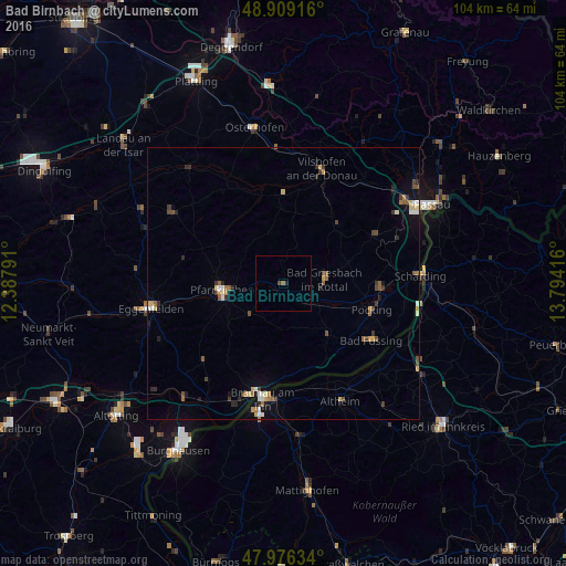
Analysis of Bad Birnbach night lights 2016
Square area 10x10 km:
 0%
0%90-99
0%80-89
0%70-79
0%60-69
0%50-59
0.57%40-49
0.14%30-39
0.43%20-29
0.43%10-19
0.14%0-9
98.3%Square area 50x50 km:
0.21%90-99
0.28%80-89
0.33%70-79
0.22%60-69
0.34%50-59
0.43%40-49
0.43%30-39
0.42%20-29
0.46%10-19
0.91%0-9
95.96%Clear (daylight) street map image can be seen on geolist.org.
Map coordinates:
48° 54' 33" North, 12° 23' 16.5" East
48° 26' 41.6" North, 13° 5' 27.7" East
47° 58' 34.8" North, 13° 47' 39" East
Some cities around Bad Birnbach sort by population:
• Pocking
17.1 km =10.6 mi,  106°
106°
• Pfarrkirchen
11.4 km =7.1 mi,  262°
262°
• Bad Griesbach
7.6 km =4.7 mi,  84°
84°
• Fürstenzell
18.7 km =11.6 mi,  62°
62°
• Ortenburg
14.8 km =9.2 mi,  40°
40°
• Bad Füssing
19.4 km =12.1 mi,  122°
122°
• Triftern
8.4 km =5.2 mi,  228°
228°
• Rotthalmünster
12.6 km =7.8 mi,  139°
139°
2948384 (p: 5,533)
Sources (retrieved 2019-11-25):
» Earth at Night: Flat Maps 2012, 2016