Schwarzenbek night lights from space
Night Light of Schwarzenbek (Schleswig-Holstein) from space (Germany) Src. Average luminocity for 10x10km area is 3.1574% and for 50x50km: 6.8156%.
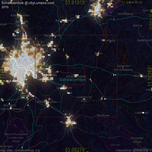
Analysis of Schwarzenbek night lights 2016
Square area 10x10 km:
 0%
0%90-99
0.53%80-89
0.66%70-79
0.93%60-69
0.53%50-59
0%40-49
1.06%30-39
0%20-29
0%10-19
0%0-9
96.3%Square area 50x50 km:
1.02%90-99
1.05%80-89
0.64%70-79
0.68%60-69
0.9%50-59
1.07%40-49
1.38%30-39
0.94%20-29
1.61%10-19
4.58%0-9
86.14%Clear (daylight) street map image can be seen on geolist.org.
Map coordinates:
53° 55' 9" North, 9° 46' 38.7" East
53° 30' 10.9" North, 10° 28' 50" East
53° 4' 57.9" North, 11° 11' 1.2" East
Some cities around Schwarzenbek sort by population:
• Bergedorf
16.8 km =10.4 mi,  262°
262°
• Geesthacht
10.1 km =6.3 mi,  222°
222°
• Reinbek
15.4 km =9.6 mi,  275°
275°
• Mölln
18.6 km =11.6 mi,  47°
47°
• Wentorf bei Hamburg
15.3 km =9.5 mi,  268°
268°
• Lauenburg
15.4 km =9.6 mi,  160°
160°
• Trittau
13.7 km =8.5 mi,  337°
337°
• Büchen
9.4 km =5.8 mi,  105°
105°
2835013 (p: 14,832)
Sources (retrieved 2019-11-25):
» Earth at Night: Flat Maps 2012, 2016