Schwaikheim night lights from space
Night Light of Schwaikheim (Baden-Württemberg) from space (Germany) Src. Average luminocity for 10x10km area is 28.0099% and for 50x50km: 25.275%.
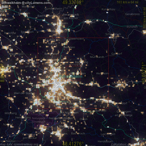
Analysis of Schwaikheim night lights 2016
Square area 10x10 km:
 2.41%
2.41%90-99
2.84%80-89
3.41%70-79
2.27%60-69
5.54%50-59
3.13%40-49
3.27%30-39
3.13%20-29
11.36%10-19
51.56%0-9
11.08%Square area 50x50 km:
4.19%90-99
4.64%80-89
2.11%70-79
2.96%60-69
3.52%50-59
3.35%40-49
3.84%30-39
3.95%20-29
8.41%10-19
14.49%0-9
48.54%Clear (daylight) street map image can be seen on geolist.org.
Map coordinates:
49° 20' 15.4" North, 8° 38' 47.3" East
48° 52' 38.4" North, 9° 20' 58.5" East
48° 24' 45.9" North, 10° 3' 9.8" East
Some cities around Schwaikheim sort by population:
• Waiblingen
5.6 km =3.5 mi,  205°
205°
• Fellbach
9.3 km =5.8 mi,  215°
215°
• Winnenden
3.6 km =2.2 mi,  93°
93°
• Weinstadt-Endersbach
7.2 km =4.5 mi,  171°
171°
• Marbach am Neckar
9.5 km =5.9 mi,  316°
316°
• Leutenbach
3.4 km =2.1 mi,  69°
69°
• Korb
3.9 km =2.4 mi, 165°
• Mittelschöntal
8.3 km =5.2 mi,  23°
23°
2835385 (p: 9,295)
Sources (retrieved 2019-11-25):
» Earth at Night: Flat Maps 2012, 2016