Mittelschöntal night lights from space
Night Light of Mittelschöntal (Baden-Württemberg) from space (Germany) Src. Average luminocity for 10x10km area is 16.4006% and for 50x50km: 20.9324%.
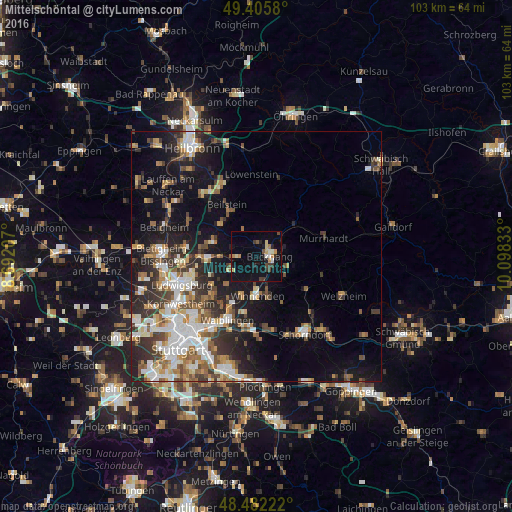
Analysis of Mittelschöntal night lights 2016
Square area 10x10 km:
 0.71%
0.71%90-99
2.13%80-89
2.7%70-79
2.41%60-69
1.14%50-59
1.14%40-49
1.99%30-39
3.13%20-29
3.13%10-19
16.9%0-9
64.63%Square area 50x50 km:
3.72%90-99
4.05%80-89
1.59%70-79
2.47%60-69
2.83%50-59
2.9%40-49
2.98%30-39
3.48%20-29
5.48%10-19
10.93%0-9
59.58%Clear (daylight) street map image can be seen on geolist.org.
Map coordinates:
49° 24' 20.9" North, 8° 41' 31.5" East
48° 56' 46.1" North, 9° 23' 42.7" East
48° 28' 56" North, 10° 5' 54" East
Some cities around Mittelschöntal sort by population:
• Backnang
3.1 km =1.9 mi,  87°
87°
• Winnenden
7.8 km =4.8 mi,  178°
178°
• Steinheim am der Murr
9 km =5.6 mi,  285°
285°
• Leutenbach
6.5 km =4 mi, 181°
• Schwaikheim
8.3 km =5.2 mi,  203°
203°
• Großbottwar
9.6 km =6 mi,  309°
309°
• Aspach
2.3 km =1.4 mi,  8°
8°
• Sulzbach an der Murr
9.9 km =6.2 mi,  50°
50°
2870584 (p: 5,872)
Sources (retrieved 2019-11-25):
» Earth at Night: Flat Maps 2012, 2016