Korb night lights from space
Night Light of Korb (Baden-Württemberg) from space (Germany) Src. Average luminocity for 10x10km area is 35.9432% and for 50x50km: 25.9214%.
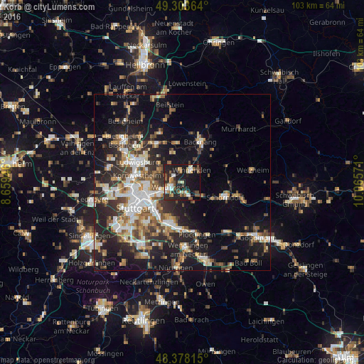
Analysis of Korb night lights 2016
Square area 10x10 km:
 4.55%
4.55%90-99
5.82%80-89
2.56%70-79
2.84%60-69
6.96%50-59
5.97%40-49
5.82%30-39
4.12%20-29
15.34%10-19
39.06%0-9
6.96%Square area 50x50 km:
4.12%90-99
4.74%80-89
2.16%70-79
2.99%60-69
3.74%50-59
3.51%40-49
4.01%30-39
4.04%20-29
8.38%10-19
15.92%0-9
46.4%Clear (daylight) street map image can be seen on geolist.org.
Map coordinates:
49° 18' 13.1" North, 8° 39' 34.1" East
48° 50' 34.9" North, 9° 21' 45.3" East
48° 22' 41.3" North, 10° 3' 56.6" East
Some cities around Korb sort by population:
• Waiblingen
3.6 km =2.2 mi,  250°
250°
• Fellbach
7.3 km =4.5 mi,  238°
238°
• Winnenden
4.5 km =2.8 mi,  35°
35°
• Weinstadt-Endersbach
3.3 km =2.1 mi,  178°
178°
• Stuttgart Mühlhausen
9.7 km =6 mi,  269°
269°
• Leutenbach
5.5 km =3.4 mi,  23°
23°
• Schwaikheim
3.9 km =2.4 mi,  345°
345°
• Winterbach
9.8 km =6.1 mi,  119°
119°
2885540 (p: 10,459)
Sources (retrieved 2019-11-25):
» Earth at Night: Flat Maps 2012, 2016