Schrobenhausen night lights from space
Night Light of Schrobenhausen (Bavaria) from space (Germany) Src. Average luminocity for 10x10km area is 5.0313% and for 50x50km: 5.0185%.
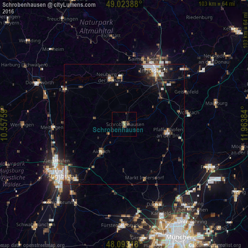
Analysis of Schrobenhausen night lights 2016
Square area 10x10 km:
 0%
0%90-99
0.15%80-89
1.04%70-79
0.6%60-69
0.74%50-59
0.6%40-49
1.79%30-39
2.23%20-29
1.79%10-19
0%0-9
91.07%Square area 50x50 km:
0.78%90-99
0.82%80-89
0.48%70-79
0.44%60-69
0.5%50-59
0.63%40-49
0.8%30-39
1.07%20-29
1.57%10-19
2.51%0-9
90.41%Clear (daylight) street map image can be seen on geolist.org.
Map coordinates:
49° 1' 26" North, 10° 33' 27.3" East
48° 33' 38.4" North, 11° 15' 38.6" East
48° 5' 35.4" North, 11° 57' 49.8" East
Some cities around Schrobenhausen sort by population:
• Neuburg an der Donau
19.8 km =12.3 mi,  344°
344°
• Pfaffenhofen an der Ilm
18.3 km =11.4 mi,  100°
100°
• Aichach
14.8 km =9.2 mi,  219°
219°
• Reichertshofen
18.6 km =11.6 mi,  54°
54°
• Altomünster
19.2 km =11.9 mi,  180°
180°
• Pöttmes
13 km =8.1 mi,  281°
281°
• Schwabhausen
19.1 km =11.9 mi,  158°
158°
• Karlshuld
13.6 km =8.5 mi,  7°
7°
2836084 (p: 16,143)
Sources (retrieved 2019-11-25):
» Earth at Night: Flat Maps 2012, 2016