Schwabhausen night lights from space
Night Light of Schwabhausen (Bavaria) from space (Germany) Src. Average luminocity for 10x10km area is 0.6889% and for 50x50km: 7.7269%.
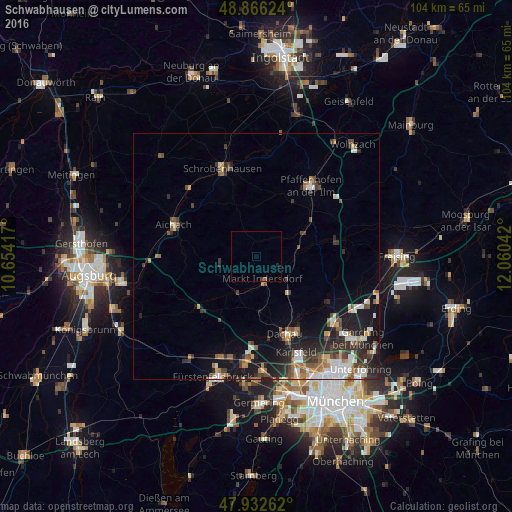
Analysis of Schwabhausen night lights 2016
Square area 10x10 km:
 0%
0%90-99
0%80-89
0%70-79
0%60-69
0%50-59
0.57%40-49
0%30-39
0.57%20-29
0.57%10-19
0%0-9
98.3%Square area 50x50 km:
1.21%90-99
1.19%80-89
0.69%70-79
0.67%60-69
1.03%50-59
1.16%40-49
1.21%30-39
1.53%20-29
2.6%10-19
4.78%0-9
83.92%Clear (daylight) street map image can be seen on geolist.org.
Map coordinates:
48° 51' 58.5" North, 10° 39' 15" East
48° 24' 5.7" North, 11° 21' 26.2" East
47° 55' 57.4" North, 12° 3' 37.5" East
Some cities around Schwabhausen sort by population:
• Dachau
16.7 km =10.4 mi,  160°
160°
• Markt Indersdorf
4.8 km =3 mi, 161°
• Altomünster
7.6 km =4.7 mi,  258°
258°
• Bergkirchen
16.1 km =10 mi,  178°
178°
• Röhrmoos
10.4 km =6.5 mi,  140°
140°
• Petershausen
8.4 km =5.2 mi,  83°
83°
• Erdweg
8.7 km =5.4 mi,  207°
207°
• Hebertshausen
14.8 km =9.2 mi,  147°
147°
2835496 (p: 5,911)
Sources (retrieved 2019-11-25):
» Earth at Night: Flat Maps 2012, 2016