Schonungen night lights from space
Night Light of Schonungen (Bavaria) from space (Germany) Src. Average luminocity for 10x10km area is 14.8109% and for 50x50km: 2.7748%.
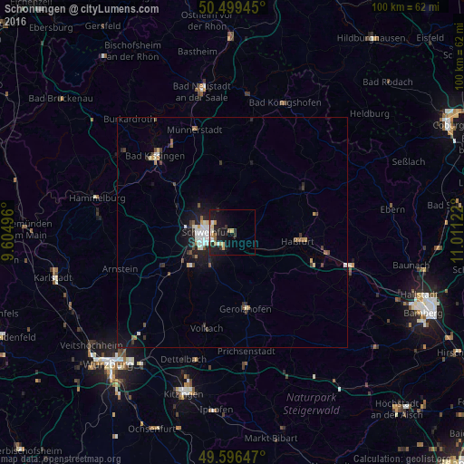
Analysis of Schonungen night lights 2016
Square area 10x10 km:
 2.24%
2.24%90-99
2.24%80-89
2.1%70-79
2.24%60-69
1.26%50-59
1.68%40-49
0%30-39
1.68%20-29
5.04%10-19
18.07%0-9
63.45%Square area 50x50 km:
0.43%90-99
0.49%80-89
0.22%70-79
0.24%60-69
0.23%50-59
0.27%40-49
0.44%30-39
0.42%20-29
0.7%10-19
2.39%0-9
94.15%Clear (daylight) street map image can be seen on geolist.org.
Map coordinates:
50° 29' 58" North, 9° 36' 17.9" East
50° 3' 0.3" North, 10° 18' 29.1" East
49° 35' 47.3" North, 11° 0' 40.4" East
Some cities around Schonungen sort by population:
• Schweinfurt
6.2 km =3.9 mi,  269°
269°
• Haßfurt
14.9 km =9.3 mi,  96°
96°
• Werneck
16.8 km =10.4 mi,  243°
243°
• Niederwerrn
9 km =5.6 mi,  278°
278°
• Dittelbrunn
6.8 km =4.2 mi,  291°
291°
• Gochsheim
4.1 km =2.5 mi,  205°
205°
• Kolitzheim
15.8 km =9.8 mi,  199°
199°
• Oerlenbach
16.7 km =10.4 mi,  311°
311°
2836455 (p: 8,230)
Sources (retrieved 2019-11-25):
» Earth at Night: Flat Maps 2012, 2016