Kolitzheim night lights from space
Night Light of Kolitzheim (Bavaria) from space (Germany) Src. Average luminocity for 10x10km area is 0.1022% and for 50x50km: 4.9746%.
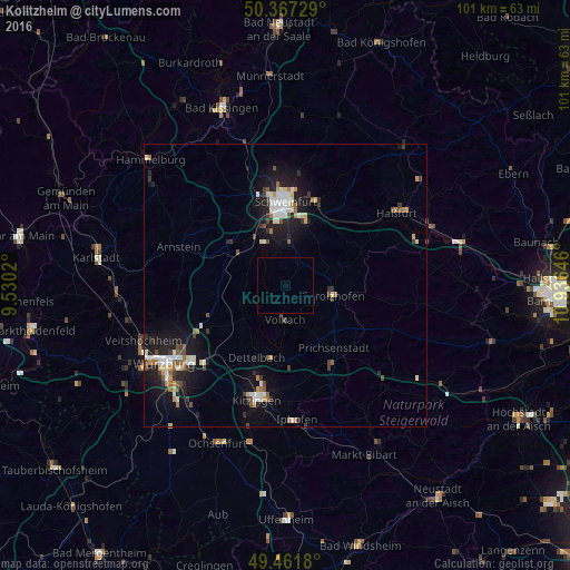
Analysis of Kolitzheim night lights 2016
Square area 10x10 km:
 0%
0%90-99
0%80-89
0%70-79
0%60-69
0%50-59
0%40-49
0%30-39
0%20-29
0%10-19
0%0-9
100%Square area 50x50 km:
0.76%90-99
0.96%80-89
0.38%70-79
0.44%60-69
0.46%50-59
0.56%40-49
0.65%30-39
0.7%20-29
1.15%10-19
4.75%0-9
89.2%Clear (daylight) street map image can be seen on geolist.org.
Map coordinates:
50° 22' 2.2" North, 9° 31' 48.7" East
49° 55' 0" North, 10° 13' 60" East
49° 27' 42.5" North, 10° 56' 11.3" East
Some cities around Kolitzheim sort by population:
• Schweinfurt
14.8 km =9.2 mi,  356°
356°
• Werneck
12.1 km =7.5 mi,  307°
307°
• Volkach
5.9 km =3.7 mi,  183°
183°
• Schonungen
15.8 km =9.8 mi,  19°
19°
• Niederwerrn
16.5 km =10.3 mi,  347°
347°
• Dettelbach
13.6 km =8.5 mi,  201°
201°
• Gerolzhofen
8.4 km =5.2 mi,  102°
102°
• Gochsheim
11.7 km =7.3 mi, 17°
2886404 (p: 5,602)
Sources (retrieved 2019-11-25):
» Earth at Night: Flat Maps 2012, 2016