Oerlenbach night lights from space
Night Light of Oerlenbach (Bavaria) from space (Germany) Src. Average luminocity for 10x10km area is 3.0762% and for 50x50km: 2.6198%.
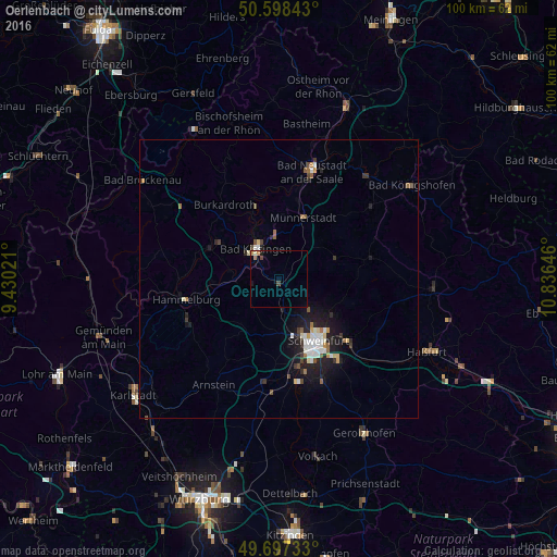
Analysis of Oerlenbach night lights 2016
Square area 10x10 km:
 0%
0%90-99
0.53%80-89
0.27%70-79
0.8%60-69
0.53%50-59
0%40-49
1.07%30-39
0%20-29
0.13%10-19
0.94%0-9
95.72%Square area 50x50 km:
0.42%90-99
0.5%80-89
0.2%70-79
0.21%60-69
0.27%50-59
0.27%40-49
0.33%30-39
0.34%20-29
0.74%10-19
2.19%0-9
94.53%Clear (daylight) street map image can be seen on geolist.org.
Map coordinates:
50° 35' 54.3" North, 9° 25' 48.8" East
50° 9' 0" North, 10° 7' 60" East
49° 41' 50.4" North, 10° 50' 11.3" East
Some cities around Oerlenbach sort by population:
• Schweinfurt
12.8 km =8 mi,  150°
150°
• Bad Kissingen
7 km =4.3 mi,  325°
325°
• Schonungen
16.7 km =10.4 mi,  131°
131°
• Münnerstadt
11.8 km =7.3 mi,  24°
24°
• Niederwerrn
10.5 km =6.5 mi,  160°
160°
• Burkardroth
16.8 km =10.4 mi,  323°
323°
• Dittelbrunn
10.6 km =6.6 mi,  144°
144°
• Oberthulba
13.6 km =8.5 mi,  293°
293°
2857075 (p: 5,411)
Sources (retrieved 2019-11-25):
» Earth at Night: Flat Maps 2012, 2016