Schöningen night lights from space
Night Light of Schöningen (Lower Saxony) from space (Germany) Src. Average luminocity for 10x10km area is 2.5198% and for 50x50km: 0.8836%.
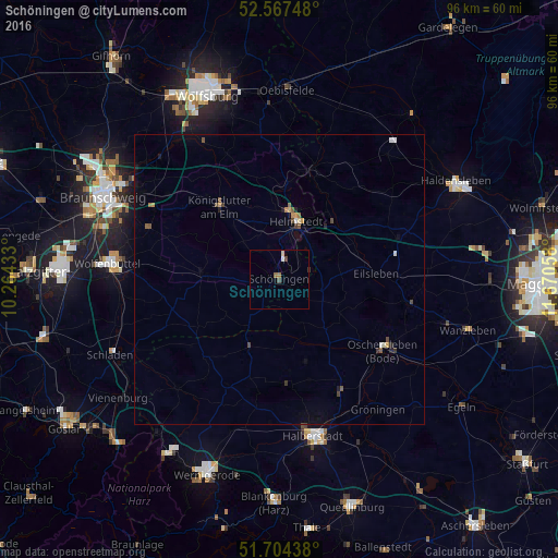
Analysis of Schöningen night lights 2016
Square area 10x10 km:
 0.13%
0.13%90-99
0.4%80-89
0.53%70-79
0%60-69
0.79%50-59
0.26%40-49
0.93%30-39
0.4%20-29
0%10-19
0%0-9
96.56%Square area 50x50 km:
0.05%90-99
0.07%80-89
0.06%70-79
0.13%60-69
0.13%50-59
0.2%40-49
0.2%30-39
0.12%20-29
0.1%10-19
0.21%0-9
98.73%Clear (daylight) street map image can be seen on geolist.org.
Map coordinates:
52° 34' 2.9" North, 10° 15' 51.6" East
52° 8' 16.9" North, 10° 58' 2.8" East
51° 42' 15.8" North, 11° 40' 14.1" East
Some cities around Schöningen sort by population:
• Wolfenbüttel
29.2 km =18.1 mi,  275°
275°
• Halberstadt
27.6 km =17.1 mi,  167°
167°
• Helmstedt
10.4 km =6.5 mi,  16°
16°
• Oschersleben
21.5 km =13.4 mi,  123°
123°
• Königslutter am Elm
16.2 km =10.1 mi,  320°
320°
• Cremlingen
25 km =15.5 mi,  299°
299°
• Huy-Neinstedt
19.5 km =12.1 mi,  190°
190°
• Sickte
23.9 km =14.9 mi,  291°
291°
2836543 (p: 13,265)
Sources (retrieved 2019-11-25):
» Earth at Night: Flat Maps 2012, 2016