Cremlingen night lights from space
Night Light of Cremlingen (Lower Saxony) from space (Germany) Src. Average luminocity for 10x10km area is 5.8228% and for 50x50km: 8.4937%.
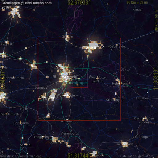
Analysis of Cremlingen night lights 2016
Square area 10x10 km:
 0%
0%90-99
0.26%80-89
0%70-79
0.79%60-69
1.19%50-59
1.85%40-49
0.4%30-39
0.26%20-29
1.85%10-19
11.24%0-9
82.14%Square area 50x50 km:
1.56%90-99
1.66%80-89
0.64%70-79
0.93%60-69
0.91%50-59
0.95%40-49
0.86%30-39
0.73%20-29
2.2%10-19
7.79%0-9
81.77%Clear (daylight) street map image can be seen on geolist.org.
Map coordinates:
52° 40' 42.2" North, 9° 56' 48.7" East
52° 15' 0" North, 10° 39' 0" East
51° 49' 2.8" North, 11° 21' 11.3" East
Some cities around Cremlingen sort by population:
• Braunschweig
8.6 km =5.3 mi,  281°
281°
• Wolfenbüttel
12.1 km =7.5 mi,  217°
217°
• Königslutter am Elm
11.4 km =7.1 mi,  89°
89°
• Lehre
9.3 km =5.8 mi,  6°
6°
• Detmerode
16.9 km =10.5 mi,  22°
22°
• Klein Schwülper
18.1 km =11.2 mi,  304°
304°
• Schöppenstedt
14.6 km =9.1 mi,  144°
144°
• Sickte
3.5 km =2.2 mi,  188°
188°
2939763 (p: 12,808)
Sources (retrieved 2019-11-25):
» Earth at Night: Flat Maps 2012, 2016