Schlüsselfeld night lights from space
Night Light of Schlüsselfeld (Bavaria) from space (Germany) Src. Average luminocity for 10x10km area is 1.4251% and for 50x50km: 3.8457%.
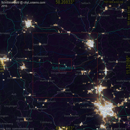
Analysis of Schlüsselfeld night lights 2016
Square area 10x10 km:
 0.4%
0.4%90-99
0.67%80-89
0%70-79
0%60-69
0%50-59
0.53%40-49
0%30-39
0%20-29
0%10-19
0%0-9
98.4%Square area 50x50 km:
0.59%90-99
0.67%80-89
0.31%70-79
0.26%60-69
0.31%50-59
0.5%40-49
0.54%30-39
0.49%20-29
1.44%10-19
3.53%0-9
91.37%Clear (daylight) street map image can be seen on geolist.org.
Map coordinates:
50° 12' 30" North, 9° 54' 56.2" East
49° 45' 22.4" North, 10° 37' 7.4" East
49° 17' 59.4" North, 11° 19' 18.7" East
Some cities around Schlüsselfeld sort by population:
• Höchstadt an der Aisch
15 km =9.3 mi,  111°
111°
• Neustadt an der Aisch
19.7 km =12.2 mi,  181°
181°
• Stegaurach
20.2 km =12.6 mi,  53°
53°
• Burgebrach
12 km =7.5 mi, 48°
• Emskirchen
23.6 km =14.7 mi,  163°
163°
• Weisendorf
21 km =13 mi,  134°
134°
• Bischberg
23 km =14.3 mi,  41°
41°
• Hemhofen
24 km =14.9 mi, 109°
2838167 (p: 5,848)
Sources (retrieved 2019-11-25):
» Earth at Night: Flat Maps 2012, 2016