Höchstadt an der Aisch night lights from space
Night Light of Höchstadt an der Aisch (Bavaria) from space (Germany) Src. Average luminocity for 10x10km area is 6.8877% and for 50x50km: 8.0317%.
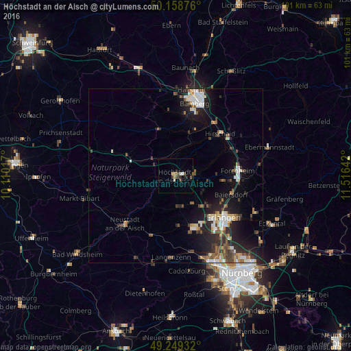
Analysis of Höchstadt an der Aisch night lights 2016
Square area 10x10 km:
 0.4%
0.4%90-99
1.2%80-89
0%70-79
1.87%60-69
0.27%50-59
0.94%40-49
1.87%30-39
1.2%20-29
1.87%10-19
0.8%0-9
89.57%Square area 50x50 km:
1.21%90-99
1.27%80-89
0.79%70-79
0.66%60-69
0.84%50-59
1.12%40-49
1.43%30-39
1.18%20-29
3.04%10-19
5.63%0-9
82.84%Clear (daylight) street map image can be seen on geolist.org.
Map coordinates:
50° 9' 31.5" North, 10° 6' 36.6" East
49° 42' 22.2" North, 10° 48' 47.8" East
49° 14' 57.6" North, 11° 30' 59.1" East
Some cities around Höchstadt an der Aisch sort by population:
• Herzogenaurach
16.2 km =10.1 mi,  161°
161°
• Hirschaid
17.7 km =11 mi,  45°
45°
• Baiersdorf
16.9 km =10.5 mi,  108°
108°
• Burgebrach
14.5 km =9 mi,  339°
339°
• Weisendorf
9.3 km =5.8 mi,  174°
174°
• Schlüsselfeld
15 km =9.3 mi,  291°
291°
• Hemhofen
9 km =5.6 mi, 106°
• Heroldsbach
13.4 km =8.3 mi,  96°
96°
2903016 (p: 13,418)
Sources (retrieved 2019-11-25):
» Earth at Night: Flat Maps 2012, 2016