Halver night lights from space
Night Light of Halver (North Rhine-Westphalia) from space (Germany) Src. Average luminocity for 10x10km area is 2.8877% and for 50x50km: 11.8666%.
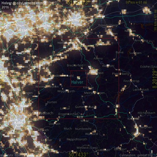
Analysis of Halver night lights 2016
Square area 10x10 km:
 0%
0%90-99
0.4%80-89
0.53%70-79
0.53%60-69
0.67%50-59
0%40-49
0.53%30-39
0.53%20-29
0%10-19
0%0-9
96.79%Square area 50x50 km:
1.09%90-99
1.56%80-89
1.14%70-79
1.66%60-69
1.72%50-59
1.78%40-49
2.02%30-39
1.42%20-29
3.38%10-19
11.66%0-9
72.58%Clear (daylight) street map image can be seen on geolist.org.
Map coordinates:
51° 37' 29" North, 6° 47' 42.1" East
51° 11' 10" North, 7° 29' 53.4" East
50° 44' 35.9" North, 8° 12' 4.6" East
Some cities around Halver sort by population:
• Lüdenscheid
9.7 km =6 mi,  67°
67°
• Radevormwald
9.8 km =6.1 mi,  280°
280°
• Wipperfürth
10.4 km =6.5 mi,  221°
221°
• Kierspe
8.7 km =5.4 mi,  131°
131°
• Hückeswagen
11.4 km =7.1 mi,  249°
249°
• Marienheide
11.7 km =7.3 mi,  168°
168°
• Schalksmühle
6.5 km =4 mi,  18°
18°
• Breckerfeld
8.4 km =5.2 mi,  345°
345°
2911384 (p: 17,650)
Sources (retrieved 2019-11-25):
» Earth at Night: Flat Maps 2012, 2016