Rüdesheim am Rhein night lights from space
Night Light of Rüdesheim am Rhein (Hesse) from space (Germany) Src. Average luminocity for 10x10km area is 19.1611% and for 50x50km: 8.9922%.
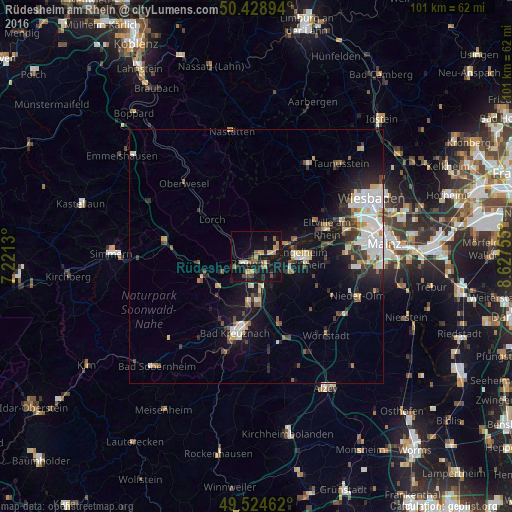
Analysis of Rüdesheim am Rhein night lights 2016
Square area 10x10 km:
 0.98%
0.98%90-99
1.12%80-89
2.24%70-79
3.64%60-69
3.08%50-59
2.24%40-49
3.92%30-39
1.68%20-29
4.34%10-19
27.31%0-9
49.44%Square area 50x50 km:
1.82%90-99
1.74%80-89
0.74%70-79
0.72%60-69
0.85%50-59
0.98%40-49
1.15%30-39
1.27%20-29
1.93%10-19
7.09%0-9
81.71%Clear (daylight) street map image can be seen on geolist.org.
Map coordinates:
50° 25' 44.2" North, 7° 13' 16.7" East
49° 58' 44" North, 7° 55' 27.9" East
49° 31' 28.6" North, 8° 37' 39.2" East
Some cities around Rüdesheim am Rhein sort by population:
• Bad Kreuznach
15.8 km =9.8 mi,  195°
195°
• Ingelheim am Rhein
9.7 km =6 mi,  95°
95°
• Bingen am Rhein
2.3 km =1.4 mi,  233°
233°
• Nieder-Ingelheim
10.6 km =6.6 mi,  90°
90°
• Eltville
14.9 km =9.3 mi,  68°
68°
• Geisenheim
3.2 km =2 mi,  78°
78°
• Budenheim
17.8 km =11.1 mi, 76°
• Gau-Algesheim
7 km =4.3 mi,  110°
110°
2843395 (p: 9,921)
Sources (retrieved 2019-11-25):
» Earth at Night: Flat Maps 2012, 2016