Gau-Algesheim night lights from space
Night Light of Gau-Algesheim (Rheinland-Pfalz) from space (Germany) Src. Average luminocity for 10x10km area is 22.0126% and for 50x50km: 12.067%.
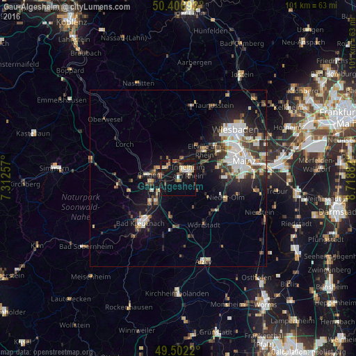
Analysis of Gau-Algesheim night lights 2016
Square area 10x10 km:
 1.96%
1.96%90-99
3.08%80-89
3.78%70-79
2.8%60-69
3.78%50-59
0.98%40-49
2.24%30-39
2.1%20-29
2.52%10-19
35.43%0-9
41.32%Square area 50x50 km:
2.35%90-99
2.33%80-89
1.07%70-79
1.05%60-69
1.11%50-59
1.29%40-49
1.68%30-39
2.07%20-29
3.1%10-19
8.67%0-9
75.29%Clear (daylight) street map image can be seen on geolist.org.
Map coordinates:
50° 24' 24.9" North, 7° 18' 45.3" East
49° 57' 24.1" North, 8° 0' 56.5" East
49° 30' 7.9" North, 8° 43' 7.8" East
Some cities around Gau-Algesheim sort by population:
• Ingelheim am Rhein
3.5 km =2.2 mi,  63°
63°
• Bingen am Rhein
8.4 km =5.2 mi,  277°
277°
• Nieder-Ingelheim
4.7 km =2.9 mi, 60°
• Eltville
10.8 km =6.7 mi,  42°
42°
• Geisenheim
4.6 km =2.9 mi,  312°
312°
• Rüdesheim am Rhein
7 km =4.3 mi,  290°
290°
• Budenheim
12.7 km =7.9 mi, 58°
• Ober-Saulheim
13.4 km =8.3 mi,  140°
140°
2922309 (p: 6,553)
Sources (retrieved 2019-11-25):
» Earth at Night: Flat Maps 2012, 2016