Cadolzburg night lights from space
Night Light of Cadolzburg (Bavaria) from space (Germany) Src. Average luminocity for 10x10km area is 3.3291% and for 50x50km: 13.5178%.
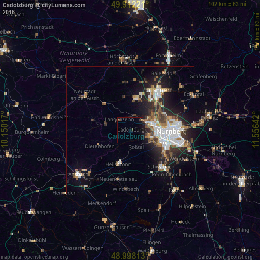
Analysis of Cadolzburg night lights 2016
Square area 10x10 km:
 0%
0%90-99
0%80-89
0.14%70-79
0.42%60-69
0.28%50-59
0.14%40-49
2.1%30-39
0.28%20-29
0.28%10-19
4.06%0-9
92.3%Square area 50x50 km:
2.94%90-99
2.33%80-89
1.1%70-79
1.16%60-69
1.51%50-59
1.87%40-49
1.87%30-39
2.04%20-29
4.3%10-19
7.42%0-9
73.45%Clear (daylight) street map image can be seen on geolist.org.
Map coordinates:
49° 54' 44" North, 10° 9' 0.6" East
49° 27' 26.3" North, 10° 51' 11.8" East
48° 59' 53.3" North, 11° 33' 23.1" East
Some cities around Cadolzburg sort by population:
• Fürth
10 km =6.2 mi,  78°
78°
• Zirndorf
7.5 km =4.7 mi,  102°
102°
• Oberasbach
8.5 km =5.3 mi,  116°
116°
• Langenzenn
6.1 km =3.8 mi,  313°
313°
• Roßtal
7.3 km =4.5 mi,  159°
159°
• Adelsdorf
12.2 km =7.6 mi,  276°
276°
• Veitsbronn
6.6 km =4.1 mi,  22°
22°
• Wilhermsdorf
10.4 km =6.5 mi,  286°
286°
2940428 (p: 10,164)
Sources (retrieved 2019-11-25):
» Earth at Night: Flat Maps 2012, 2016