Rennertshofen night lights from space
Night Light of Rennertshofen (Bavaria) from space (Germany) Src. Average luminocity for 10x10km area is 0.0199% and for 50x50km: 2.3414%.
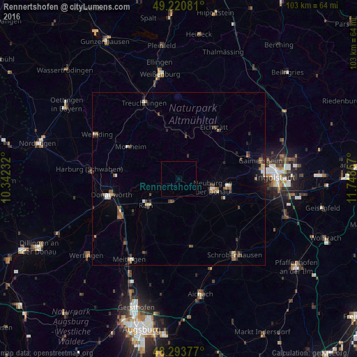
Analysis of Rennertshofen night lights 2016
Square area 10x10 km:
 0%
0%90-99
0%80-89
0%70-79
0%60-69
0%50-59
0%40-49
0%30-39
0%20-29
0%10-19
0%0-9
100%Square area 50x50 km:
0.25%90-99
0.27%80-89
0.23%70-79
0.17%60-69
0.3%50-59
0.43%40-49
0.56%30-39
0.37%20-29
0.53%10-19
0.78%0-9
96.1%Clear (daylight) street map image can be seen on geolist.org.
Map coordinates:
49° 13' 14.9" North, 10° 20' 32.4" East
48° 45' 33.9" North, 11° 2' 43.6" East
48° 17' 37.6" North, 11° 44' 54.9" East
Some cities around Rennertshofen sort by population:
• Neuburg an der Donau
10.8 km =6.7 mi,  106°
106°
• Donauwörth
20.1 km =12.5 mi,  256°
256°
• Treuchtlingen
23.9 km =14.9 mi,  335°
335°
• Eichstätt
18.1 km =11.2 mi,  37°
37°
• Gaimersheim
24.2 km =15 mi,  77°
77°
• Rain
12.2 km =7.6 mi,  230°
230°
• Pöttmes
19.8 km =12.3 mi,  170°
170°
• Karlshuld
19.6 km =12.2 mi,  116°
116°
2848181 (p: 5,013)
Sources (retrieved 2019-11-25):
» Earth at Night: Flat Maps 2012, 2016