Bad Breisig night lights from space
Night Light of Bad Breisig (Rheinland-Pfalz) from space (Germany) Src. Average luminocity for 10x10km area is 8.0994% and for 50x50km: 10.6806%.
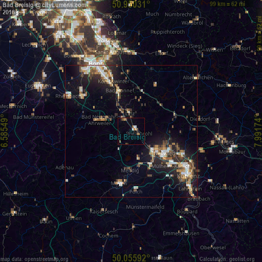
Analysis of Bad Breisig night lights 2016
Square area 10x10 km:
 1.12%
1.12%90-99
0.56%80-89
0.56%70-79
0.98%60-69
0.84%50-59
2.1%40-49
1.4%30-39
0.56%20-29
1.4%10-19
0.28%0-9
90.2%Square area 50x50 km:
1.2%90-99
1.81%80-89
0.97%70-79
0.93%60-69
1.54%50-59
1.68%40-49
1.91%30-39
1.42%20-29
3.32%10-19
7.61%0-9
77.61%Clear (daylight) street map image can be seen on geolist.org.
Map coordinates:
50° 57' 1.1" North, 6° 35' 7.8" East
50° 30' 18.8" North, 7° 17' 19" East
50° 3' 21.3" North, 7° 59' 30.3" East
Some cities around Bad Breisig sort by population:
• Neuwied
15.1 km =9.4 mi,  121°
121°
• Andernach
11.6 km =7.2 mi,  135°
135°
• Bad Neuenahr-Ahrweiler
13.2 km =8.2 mi,  288°
288°
• Sinzig
5.2 km =3.2 mi,  325°
325°
• Remagen
9.3 km =5.8 mi, 331°
• Linz am Rhein
7.1 km =4.4 mi,  357°
357°
• Plaidt
14.5 km =9 mi,  149°
149°
• Bad Hönningen
2.1 km =1.3 mi,  51°
51°
2953536 (p: 8,959)
Sources (retrieved 2019-11-25):
» Earth at Night: Flat Maps 2012, 2016