Michelstadt night lights from space
Night Light of Michelstadt (Hesse) from space (Germany) Src. Average luminocity for 10x10km area is 5.8128% and for 50x50km: 3.1292%.
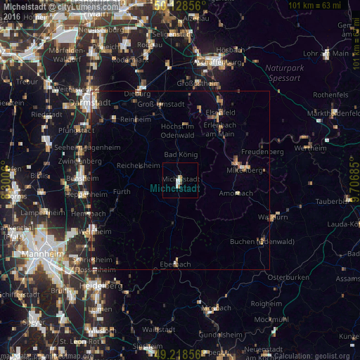
Analysis of Michelstadt night lights 2016
Square area 10x10 km:
 1.6%
1.6%90-99
1.07%80-89
0.53%70-79
0.27%60-69
1.34%50-59
0.4%40-49
0.13%30-39
0%20-29
0.53%10-19
0%0-9
94.12%Square area 50x50 km:
0.3%90-99
0.38%80-89
0.28%70-79
0.31%60-69
0.46%50-59
0.56%40-49
0.46%30-39
0.31%20-29
0.69%10-19
2%0-9
94.25%Clear (daylight) street map image can be seen on geolist.org.
Map coordinates:
50° 7' 42.8" North, 8° 18' 2.2" East
49° 40' 32.5" North, 9° 0' 13.4" East
49° 13' 6.8" North, 9° 42' 24.7" East
Some cities around Michelstadt sort by population:
• Erbach
1.7 km =1.1 mi,  203°
203°
• Fürth
16 km =9.9 mi,  260°
260°
• Höchst im Odenwald
13.8 km =8.6 mi,  358°
358°
• Bad König
7.5 km =4.7 mi,  2°
2°
• Reichelsheim
12.5 km =7.8 mi,  288°
288°
• Beerfelden
12.1 km =7.5 mi,  190°
190°
• Lindenfels
16 km =9.9 mi,  273°
273°
• Brensbach
13.9 km =8.6 mi,  321°
321°
2871284 (p: 17,279)
Sources (retrieved 2019-11-25):
» Earth at Night: Flat Maps 2012, 2016