Benningen am Neckar night lights from space
Night Light of Benningen am Neckar (Baden-Württemberg) from space (Germany) Src. Average luminocity for 10x10km area is 34.3395% and for 50x50km: 23.0735%.
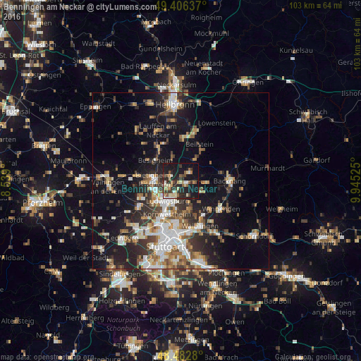
Analysis of Benningen am Neckar night lights 2016
Square area 10x10 km:
 2.27%
2.27%90-99
5.26%80-89
7.39%70-79
1.99%60-69
4.12%50-59
5.54%40-49
3.55%30-39
7.39%20-29
15.48%10-19
35.51%0-9
11.51%Square area 50x50 km:
3.97%90-99
4.32%80-89
1.83%70-79
2.55%60-69
3.08%50-59
3.01%40-49
3.2%30-39
3.67%20-29
6.56%10-19
14.36%0-9
53.44%Clear (daylight) street map image can be seen on geolist.org.
Map coordinates:
49° 24' 22.9" North, 8° 32' 20.4" East
48° 56' 48.2" North, 9° 14' 31.6" East
48° 28' 58.1" North, 9° 56' 42.9" East
Some cities around Benningen am Neckar sort by population:
• Ludwigsburg
6.6 km =4.1 mi,  213°
213°
• Marbach am Neckar
1.5 km =0.9 mi,  121°
121°
• Freiberg am Neckar
3.3 km =2.1 mi,  240°
240°
• Asperg
9.1 km =5.7 mi, 239°
• Steinheim am der Murr
3.5 km =2.2 mi,  46°
46°
• Großbottwar
7.1 km =4.4 mi,  31°
31°
• Pleidelsheim
3.2 km =2 mi,  295°
295°
• Murr
2.1 km =1.3 mi,  36°
36°
2951013 (p: 5,481)
Sources (retrieved 2019-11-25):
» Earth at Night: Flat Maps 2012, 2016