Pegnitz night lights from space
Night Light of Pegnitz (Bavaria) from space (Germany) Src. Average luminocity for 10x10km area is 1.9666% and for 50x50km: 1.7045%.
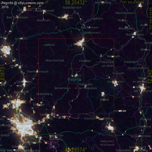
Analysis of Pegnitz night lights 2016
Square area 10x10 km:
 0%
0%90-99
0.53%80-89
0%70-79
0.27%60-69
1.34%50-59
0%40-49
0.27%30-39
0.27%20-29
0%10-19
0.13%0-9
97.19%Square area 50x50 km:
0.25%90-99
0.21%80-89
0.13%70-79
0.28%60-69
0.36%50-59
0.13%40-49
0.2%30-39
0.14%20-29
0.21%10-19
0.8%0-9
97.3%Clear (daylight) street map image can be seen on geolist.org.
Map coordinates:
50° 12' 15.6" North, 10° 50' 19.5" East
49° 45' 7.8" North, 11° 32' 30.7" East
49° 17' 44.7" North, 12° 14' 42" East
Some cities around Pegnitz sort by population:
• Bayreuth
21.9 km =13.6 mi,  6°
6°
• Auerbach
9.4 km =5.8 mi,  135°
135°
• Schnaittach
25.7 km =16 mi,  213°
213°
• Neunkirchen am Main
20.5 km =12.7 mi,  21°
21°
• Bindlach
26 km =16.2 mi, 11°
• Vilseck
24.2 km =15 mi,  129°
129°
• Speichersdorf
21.7 km =13.5 mi,  52°
52°
• Pottenstein
9.9 km =6.2 mi,  282°
282°
2855065 (p: 14,279)
Sources (retrieved 2019-11-25):
» Earth at Night: Flat Maps 2012, 2016