Auerbach night lights from space
Night Light of Auerbach (Bavaria) from space (Germany) Src. Average luminocity for 10x10km area is 1.1029% and for 50x50km: 1.7804%.
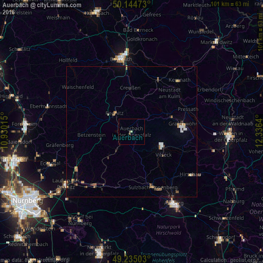
Analysis of Auerbach night lights 2016
Square area 10x10 km:
 0%
0%90-99
0%80-89
0.53%70-79
0%60-69
0%50-59
1.07%40-49
0%30-39
0%20-29
0%10-19
0%0-9
98.4%Square area 50x50 km:
0.2%90-99
0.19%80-89
0.14%70-79
0.18%60-69
0.3%50-59
0.38%40-49
0.22%30-39
0.31%20-29
0.24%10-19
0.32%0-9
97.53%Clear (daylight) street map image can be seen on geolist.org.
Map coordinates:
50° 8' 41" North, 10° 55' 48.5" East
49° 41' 31.2" North, 11° 37' 59.8" East
49° 14' 6.1" North, 12° 20' 11" East
Some cities around Auerbach sort by population:
• Sulzbach-Rosenberg
22.7 km =14.1 mi,  159°
159°
• Pegnitz
9.4 km =5.8 mi,  315°
315°
• Grafenwöhr
19.8 km =12.3 mi,  81°
81°
• Vilseck
14.9 km =9.3 mi,  125°
125°
• Speichersdorf
22.6 km =14 mi,  28°
28°
• Pottenstein
18.4 km =11.4 mi,  298°
298°
• Pommelsbrunn
22.6 km =14 mi,  202°
202°
• Hahnbach
21.4 km =13.3 mi,  145°
145°
2954603 (p: 9,089)
Sources (retrieved 2019-11-25):
» Earth at Night: Flat Maps 2012, 2016