Bindlach night lights from space
Night Light of Bindlach (Bavaria) from space (Germany) Src. Average luminocity for 10x10km area is 15.3487% and for 50x50km: 1.5565%.
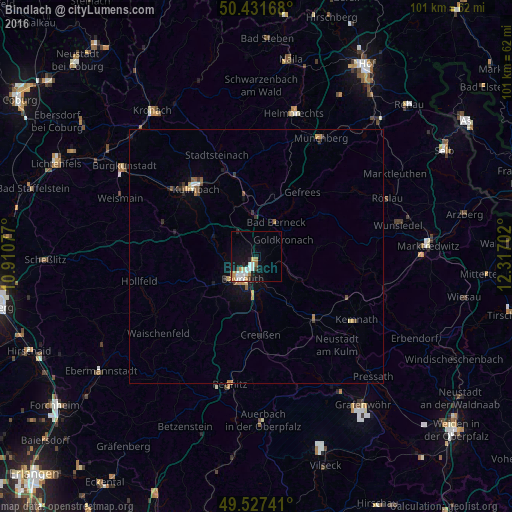
Analysis of Bindlach night lights 2016
Square area 10x10 km:
 3.92%
3.92%90-99
2.94%80-89
0.42%70-79
3.08%60-69
1.82%50-59
0.7%40-49
0.7%30-39
0.98%20-29
1.82%10-19
11.76%0-9
71.85%Square area 50x50 km:
0.18%90-99
0.18%80-89
0.13%70-79
0.28%60-69
0.22%50-59
0.15%40-49
0.19%30-39
0.29%20-29
0.16%10-19
1.05%0-9
97.17%Clear (daylight) street map image can be seen on geolist.org.
Map coordinates:
50° 25' 54" North, 10° 54' 38.8" East
49° 58' 54" North, 11° 36' 50" East
49° 31' 38.7" North, 12° 19' 1.3" East
Some cities around Bindlach sort by population:
• Bayreuth
4.5 km =2.8 mi,  213°
213°
• Kulmbach
17.7 km =11 mi,  318°
318°
• Neunkirchen am Main
7 km =4.3 mi,  159°
159°
• Mainleus
21.4 km =13.3 mi,  307°
307°
• Speichersdorf
17.1 km =10.6 mi,  135°
135°
• Kemnath
23.4 km =14.5 mi,  122°
122°
• Hollfeld
23.6 km =14.7 mi,  258°
258°
• Eckersdorf
16.4 km =10.2 mi,  288°
288°
2948840 (p: 7,229)
Sources (retrieved 2019-11-25):
» Earth at Night: Flat Maps 2012, 2016