Olbernhau night lights from space
Night Light of Olbernhau (Saxony) from space (Germany) Src. Average luminocity for 10x10km area is 1.6751% and for 50x50km: 4.2539%.
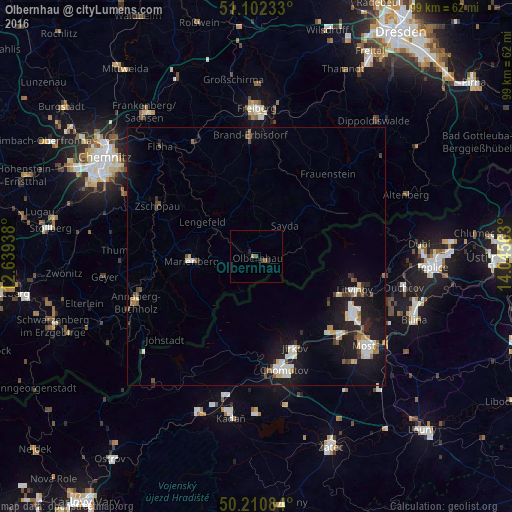
Analysis of Olbernhau night lights 2016
Square area 10x10 km:
 0%
0%90-99
0%80-89
0%70-79
0.53%60-69
0%50-59
0.53%40-49
1.07%30-39
0.53%20-29
0.27%10-19
0.8%0-9
96.26%Square area 50x50 km:
0.7%90-99
0.75%80-89
0.41%70-79
0.28%60-69
0.39%50-59
0.44%40-49
0.47%30-39
0.34%20-29
0.94%10-19
4.92%0-9
90.36%Clear (daylight) street map image can be seen on geolist.org.
Map coordinates:
51° 6' 8.4" North, 12° 38' 21.8" East
50° 39' 31.3" North, 13° 20' 33" East
50° 12' 39" North, 14° 2' 44.3" East
Some cities around Olbernhau sort by population:
• Chomutov, CZ
22.7 km =14.1 mi,  166°
166°
• Litvínov, CZ
20.4 km =12.7 mi,  107°
107°
• Annaberg-Buchholz
25.3 km =15.7 mi,  249°
249°
• Jirkov, CZ
19.2 km =11.9 mi,  157°
157°
• Marienberg
12.8 km =8 mi,  265°
265°
• Zschopau
21.2 km =13.2 mi,  298°
298°
• Brand-Erbisdorf
23.1 km =14.4 mi,  356°
356°
• Augustusburg
24 km =14.9 mi,  315°
315°
2857484 (p: 11,162)
Sources (retrieved 2019-11-25):
» Earth at Night: Flat Maps 2012, 2016