Oberthulba night lights from space
Night Light of Oberthulba (Bavaria) from space (Germany) Src. Average luminocity for 10x10km area is 0.5254% and for 50x50km: 2.6553%.
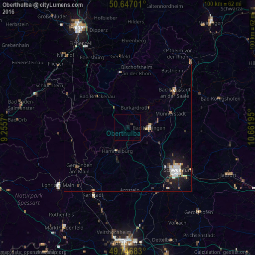
Analysis of Oberthulba night lights 2016
Square area 10x10 km:
 0%
0%90-99
0%80-89
0%70-79
0%60-69
0%50-59
0%40-49
0.13%30-39
0.4%20-29
0.53%10-19
0.53%0-9
98.4%Square area 50x50 km:
0.43%90-99
0.52%80-89
0.19%70-79
0.2%60-69
0.31%50-59
0.32%40-49
0.35%30-39
0.32%20-29
0.71%10-19
2.17%0-9
94.47%Clear (daylight) street map image can be seen on geolist.org.
Map coordinates:
50° 38' 49.2" North, 9° 15' 20.5" East
50° 11' 56.5" North, 9° 57' 31.8" East
49° 44' 48.6" North, 10° 39' 43" East
Some cities around Oberthulba sort by population:
• Bad Kissingen
8.5 km =5.3 mi,  87°
87°
• Bad Neustadt an der Saale
22.3 km =13.9 mi,  52°
52°
• Hammelburg
10.4 km =6.5 mi,  207°
207°
• Münnerstadt
18.1 km =11.2 mi,  73°
73°
• Niederwerrn
22.1 km =13.7 mi,  133°
133°
• Burkardroth
8.4 km =5.2 mi,  16°
16°
• Bad Brückenau
17.1 km =10.6 mi,  315°
315°
• Oerlenbach
13.6 km =8.5 mi,  113°
113°
2858787 (p: 5,151)
Sources (retrieved 2019-11-25):
» Earth at Night: Flat Maps 2012, 2016