Neuenstadt am Kocher night lights from space
Night Light of Neuenstadt am Kocher (Baden-Württemberg) from space (Germany) Src. Average luminocity for 10x10km area is 5.7995% and for 50x50km: 6.3662%.
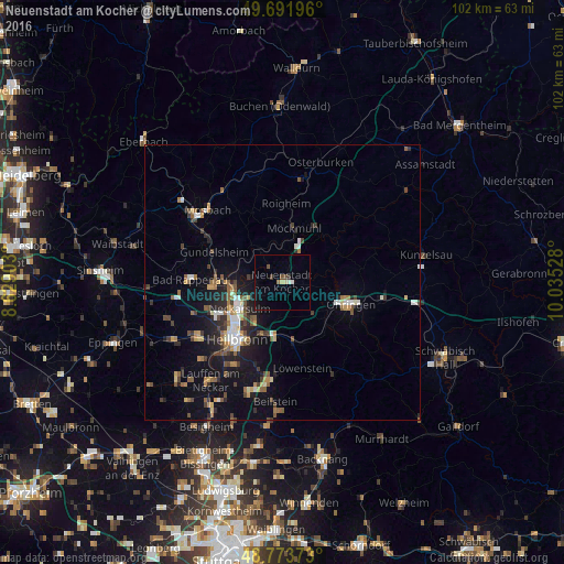
Analysis of Neuenstadt am Kocher night lights 2016
Square area 10x10 km:
 0.67%
0.67%90-99
0.4%80-89
1.07%70-79
0%60-69
0.53%50-59
0%40-49
1.6%30-39
0.94%20-29
0.13%10-19
3.07%0-9
91.58%Square area 50x50 km:
0.73%90-99
0.68%80-89
0.57%70-79
0.67%60-69
0.81%50-59
1.19%40-49
1.02%30-39
1.03%20-29
1.51%10-19
4.54%0-9
87.25%Clear (daylight) street map image can be seen on geolist.org.
Map coordinates:
49° 41' 31.1" North, 8° 37' 44.5" East
49° 14' 5.9" North, 9° 19' 55.7" East
48° 46' 25.4" North, 10° 2' 7" East
Some cities around Neuenstadt am Kocher sort by population:
• Neckarsulm
9.3 km =5.8 mi,  236°
236°
• Öhringen
13.3 km =8.3 mi,  107°
107°
• Bretzfeld
9.9 km =6.2 mi,  128°
128°
• Weinsberg
9.9 km =6.2 mi,  199°
199°
• Möckmühl
10.2 km =6.3 mi,  10°
10°
• Bad Wimpfen
12.8 km =8 mi,  267°
267°
• Oedheim
5.8 km =3.6 mi,  275°
275°
• Neudenau
7.8 km =4.8 mi,  324°
324°
2865560 (p: 9,312)
Sources (retrieved 2019-11-25):
» Earth at Night: Flat Maps 2012, 2016