Odenthal night lights from space
Night Light of Odenthal (North Rhine-Westphalia) from space (Germany) Src. Average luminocity for 10x10km area is 22.7019% and for 50x50km: 33.4663%.
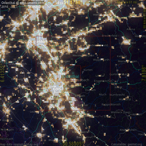
Analysis of Odenthal night lights 2016
Square area 10x10 km:
 1.87%
1.87%90-99
2.41%80-89
0%70-79
2.67%60-69
3.07%50-59
5.48%40-49
4.81%30-39
5.61%20-29
9.49%10-19
25.67%0-9
38.9%Square area 50x50 km:
6.82%90-99
7.28%80-89
2.89%70-79
3.78%60-69
4.51%50-59
4.66%40-49
4.89%30-39
7.04%20-29
9.92%10-19
9.47%0-9
38.74%Clear (daylight) street map image can be seen on geolist.org.
Map coordinates:
51° 28' 24.2" North, 6° 24' 48.8" East
51° 1' 60" North, 7° 7' 0" East
50° 35' 20.6" North, 7° 49' 11.3" East
Some cities around Odenthal sort by population:
• Leverkusen
9.3 km =5.8 mi,  267°
267°
• Bergisch Gladbach
5.4 km =3.4 mi,  167°
167°
• Mülheim
10.9 km =6.8 mi,  226°
226°
• Leichlingen
10.6 km =6.6 mi,  319°
319°
• Opladen
8.8 km =5.5 mi,  296°
296°
• Kürten
10.6 km =6.6 mi,  79°
79°
• Burscheid
5.7 km =3.5 mi,  358°
358°
• Buchheim
11.3 km =7 mi,  216°
216°
2858103 (p: 15,619)
Sources (retrieved 2019-11-25):
» Earth at Night: Flat Maps 2012, 2016