Nossen night lights from space
Night Light of Nossen (Saxony) from space (Germany) Src. Average luminocity for 10x10km area is 2.2086% and for 50x50km: 4.3644%.
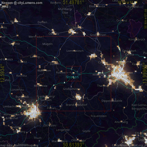
Analysis of Nossen night lights 2016
Square area 10x10 km:
 0%
0%90-99
0%80-89
0%70-79
0.53%60-69
1.07%50-59
0%40-49
0.67%30-39
1.2%20-29
0.27%10-19
0%0-9
96.26%Square area 50x50 km:
0.36%90-99
0.59%80-89
0.37%70-79
0.45%60-69
0.76%50-59
0.68%40-49
0.76%30-39
0.46%20-29
0.86%10-19
3.08%0-9
91.63%Clear (daylight) street map image can be seen on geolist.org.
Map coordinates:
51° 29' 52.1" North, 12° 35' 36.2" East
51° 3' 28.7" North, 13° 17' 47.5" East
50° 36' 50.1" North, 13° 59' 58.7" East
Some cities around Nossen sort by population:
• Freiberg
16.6 km =10.3 mi,  169°
169°
• Döbeln
14.8 km =9.2 mi,  298°
298°
• Wilsdruff
16.8 km =10.4 mi,  92°
92°
• Hainichen
15.6 km =9.7 mi,  231°
231°
• Roßwein
8 km =5 mi,  276°
276°
• Großschirma
10.3 km =6.4 mi,  184°
184°
• Klipphausen
15.2 km =9.4 mi, 85°
• Lommatzsch
15.3 km =9.5 mi,  3°
3°
2861788 (p: 7,588)
Sources (retrieved 2019-11-25):
» Earth at Night: Flat Maps 2012, 2016