Hainichen night lights from space
Night Light of Hainichen (Saxony) from space (Germany) Src. Average luminocity for 10x10km area is 1.7633% and for 50x50km: 6.1002%.
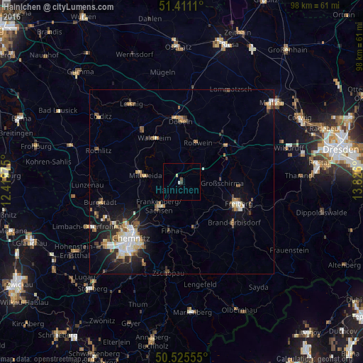
Analysis of Hainichen night lights 2016
Square area 10x10 km:
 0.56%
0.56%90-99
0%80-89
0.56%70-79
0%60-69
0%50-59
0%40-49
0.56%30-39
0.56%20-29
0%10-19
0%0-9
97.76%Square area 50x50 km:
0.82%90-99
1.09%80-89
0.82%70-79
0.58%60-69
0.81%50-59
0.84%40-49
0.77%30-39
0.64%20-29
1.63%10-19
3.68%0-9
88.33%Clear (daylight) street map image can be seen on geolist.org.
Map coordinates:
51° 24' 40" North, 12° 25' 11.1" East
50° 58' 13.6" North, 13° 7' 22.3" East
50° 31' 32" North, 13° 49' 33.6" East
Some cities around Hainichen sort by population:
• Frankenberg
8.6 km =5.3 mi,  222°
222°
• Mittweida
10.5 km =6.5 mi,  279°
279°
• Flöha
13.2 km =8.2 mi,  195°
195°
• Waldheim
13.5 km =8.4 mi,  327°
327°
• Roßwein
11.4 km =7.1 mi,  21°
21°
• Oederan
12.7 km =7.9 mi,  164°
164°
• Großschirma
11.4 km =7.1 mi,  92°
92°
• Niederwiesa
13.7 km =8.5 mi,  212°
212°
2911795 (p: 9,511)
Sources (retrieved 2019-11-25):
» Earth at Night: Flat Maps 2012, 2016