Nittendorf night lights from space
Night Light of Nittendorf (Bavaria) from space (Germany) Src. Average luminocity for 10x10km area is 2.4479% and for 50x50km: 5.3041%.
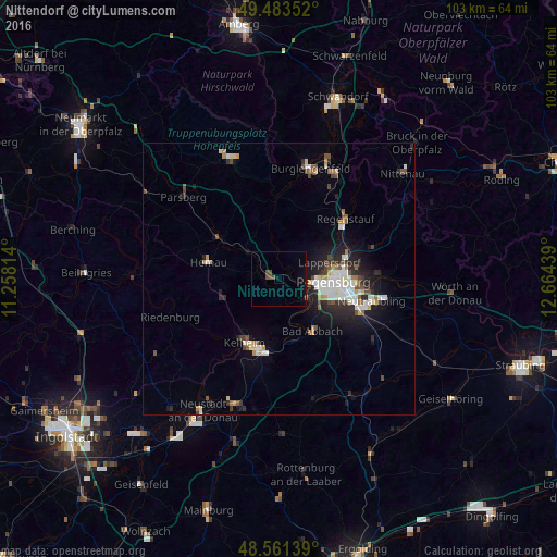
Analysis of Nittendorf night lights 2016
Square area 10x10 km:
 0%
0%90-99
0%80-89
0%70-79
0%60-69
0%50-59
0.3%40-49
2.68%30-39
0%20-29
0%10-19
0.6%0-9
96.43%Square area 50x50 km:
0.93%90-99
1.11%80-89
0.39%70-79
0.45%60-69
0.46%50-59
0.53%40-49
0.87%30-39
0.46%20-29
1.6%10-19
3.25%0-9
89.94%Clear (daylight) street map image can be seen on geolist.org.
Map coordinates:
49° 29' 0.7" North, 11° 15' 29.3" East
49° 1' 28.5" North, 11° 57' 40.5" East
48° 33' 41" North, 12° 39' 51.8" East
Some cities around Nittendorf sort by population:
• Regensburg
10.3 km =6.4 mi,  95°
95°
• Kelheim
13.1 km =8.1 mi,  204°
204°
• Lappersdorf
9.8 km =6.1 mi,  75°
75°
• Bad Abbach
11.4 km =7.1 mi,  147°
147°
• Reinhausen
11.1 km =6.9 mi,  86°
86°
• Sinzing
5.9 km =3.7 mi,  117°
117°
• Zeitlarn
12.5 km =7.8 mi,  61°
61°
• Pentling
8.5 km =5.3 mi, 122°
2862347 (p: 9,226)
Sources (retrieved 2019-11-25):
» Earth at Night: Flat Maps 2012, 2016