Reinhausen night lights from space
Night Light of Reinhausen (Bavaria) from space (Germany) Src. Average luminocity for 10x10km area is 55.5193% and for 50x50km: 5.2456%.
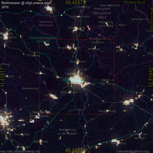
Analysis of Reinhausen night lights 2016
Square area 10x10 km:
 17.86%
90-99
17.11%80-89
3.27%70-79
3.72%60-69
4.76%50-59
3.27%40-49
4.61%30-39
4.61%20-29
14.88%10-19
21.28%0-9
4.61%Square area 50x50 km:
0.93%90-99
1.09%80-89
0.4%70-79
0.45%60-69
0.46%50-59
0.58%40-49
0.83%30-39
0.45%20-29
1.58%10-19
3.23%0-9
90%Clear (daylight) street map image can be seen on geolist.org.
Map coordinates:
49° 29' 23.2" North, 11° 24' 36.6" East
49° 1' 51.3" North, 12° 6' 47.8" East
48° 34' 4" North, 12° 48' 59.1" East
Some cities around Reinhausen sort by population:
• Regensburg
2 km =1.2 mi,  205°
205°
• Lappersdorf
2.4 km =1.5 mi,  318°
318°
• Neutraubling
8 km =5 mi,  127°
127°
• Wenzenbach
8 km =5 mi,  51°
51°
• Obertraubling
8.1 km =5 mi,  151°
151°
• Sinzing
6.8 km =4.2 mi,  239°
239°
• Zeitlarn
5.3 km =3.3 mi,  358°
358°
• Pentling
6.6 km =4.1 mi,  217°
217°
2848766 (p: 9,207)
Sources (retrieved 2019-11-25):
» Earth at Night: Flat Maps 2012, 2016