Pentling night lights from space
Night Light of Pentling (Bavaria) from space (Germany) Src. Average luminocity for 10x10km area is 30.8943% and for 50x50km: 5.2014%.
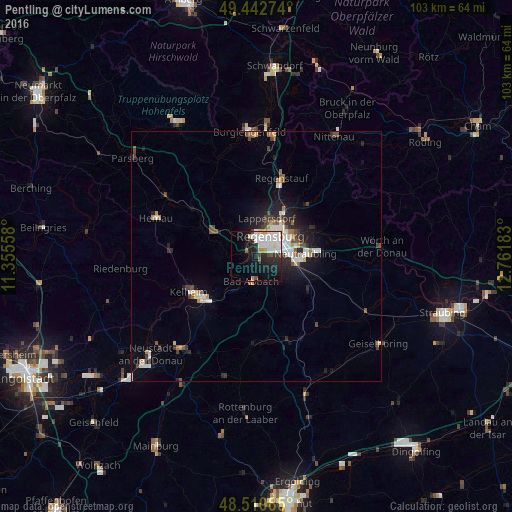
Analysis of Pentling night lights 2016
Square area 10x10 km:
 9.52%
9.52%90-99
9.38%80-89
1.34%70-79
2.38%60-69
0.74%50-59
1.49%40-49
1.79%30-39
2.08%20-29
9.67%10-19
19.05%0-9
42.56%Square area 50x50 km:
0.95%90-99
1.09%80-89
0.34%70-79
0.4%60-69
0.46%50-59
0.53%40-49
0.81%30-39
0.5%20-29
1.55%10-19
3.35%0-9
90.02%Clear (daylight) street map image can be seen on geolist.org.
Map coordinates:
49° 26' 33.9" North, 11° 21' 20.1" East
48° 59' 0.3" North, 12° 3' 31.3" East
48° 31' 11.5" North, 12° 45' 42.6" East
Some cities around Pentling sort by population:
• Regensburg
4.7 km =2.9 mi,  41°
41°
• Lappersdorf
7.5 km =4.7 mi,  18°
18°
• Neutraubling
10.4 km =6.5 mi,  87°
87°
• Bad Abbach
5.2 km =3.2 mi,  191°
191°
• Nittendorf
8.5 km =5.3 mi,  302°
302°
• Reinhausen
6.6 km =4.1 mi, 37°
• Obertraubling
8.1 km =5 mi,  103°
103°
• Sinzing
2.6 km =1.6 mi,  314°
314°
2854928 (p: 5,485)
Sources (retrieved 2019-11-25):
» Earth at Night: Flat Maps 2012, 2016