Bad Abbach night lights from space
Night Light of Bad Abbach (Bavaria) from space (Germany) Src. Average luminocity for 10x10km area is 5.2571% and for 50x50km: 5.0413%.
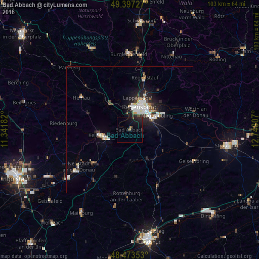
Analysis of Bad Abbach night lights 2016
Square area 10x10 km:
 0%
0%90-99
0%80-89
0%70-79
1.14%60-69
0%50-59
1.14%40-49
0.57%30-39
0%20-29
3.84%10-19
10.51%0-9
82.81%Square area 50x50 km:
0.96%90-99
1.13%80-89
0.33%70-79
0.38%60-69
0.37%50-59
0.49%40-49
0.63%30-39
0.51%20-29
1.55%10-19
3.31%0-9
90.34%Clear (daylight) street map image can be seen on geolist.org.
Map coordinates:
49° 23' 50.2" North, 11° 20' 30.6" East
48° 56' 15.1" North, 12° 2' 41.8" East
48° 28' 24.7" North, 12° 44' 53.1" East
Some cities around Bad Abbach sort by population:
• Regensburg
9.6 km =6 mi,  25°
25°
• Kelheim
11.8 km =7.3 mi,  258°
258°
• Nittendorf
11.4 km =7.1 mi,  327°
327°
• Reinhausen
11.5 km =7.1 mi, 25°
• Obertraubling
9.5 km =5.9 mi,  69°
69°
• Sinzing
7 km =4.3 mi,  353°
353°
• Saal
9.2 km =5.7 mi,  243°
243°
• Pentling
5.2 km =3.2 mi,  11°
11°
2953559 (p: 10,882)
Sources (retrieved 2019-11-25):
» Earth at Night: Flat Maps 2012, 2016