Bernhardswald night lights from space
Night Light of Bernhardswald (Bavaria) from space (Germany) Src. Average luminocity for 10x10km area is 0.7801% and for 50x50km: 5.1414%.
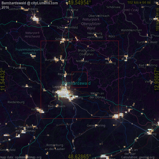
Analysis of Bernhardswald night lights 2016
Square area 10x10 km:
 0%
0%90-99
0%80-89
0%70-79
0%60-69
0%50-59
0%40-49
0.42%30-39
0.14%20-29
0%10-19
0.98%0-9
98.46%Square area 50x50 km:
0.99%90-99
1.14%80-89
0.32%70-79
0.43%60-69
0.41%50-59
0.6%40-49
0.7%30-39
0.41%20-29
1.5%10-19
3.28%0-9
90.23%Clear (daylight) street map image can be seen on geolist.org.
Map coordinates:
49° 32' 58.3" North, 11° 32' 39.6" East
49° 5' 28.4" North, 12° 14' 50.8" East
48° 37' 43.1" North, 12° 57' 2.1" East
Some cities around Bernhardswald sort by population:
• Regensburg
13.6 km =8.5 mi,  231°
231°
• Regenstauf
9.1 km =5.7 mi,  290°
290°
• Lappersdorf
12.4 km =7.7 mi,  246°
246°
• Neutraubling
12 km =7.5 mi,  196°
196°
• Reinhausen
11.9 km =7.4 mi,  235°
235°
• Nittenau
11.5 km =7.1 mi,  7°
7°
• Wenzenbach
3.9 km =2.4 mi, 243°
• Zeitlarn
10 km =6.2 mi,  261°
261°
2950019 (p: 5,596)
Sources (retrieved 2019-11-25):
» Earth at Night: Flat Maps 2012, 2016