Nienburg night lights from space
Night Light of Nienburg (Lower Saxony) from space (Germany) Src. Average luminocity for 10x10km area is 4.5741% and for 50x50km: 0.9311%.

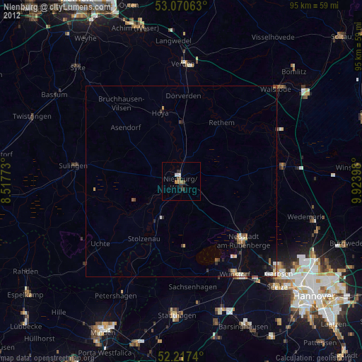
Analysis of Nienburg night lights 2016
Square area 10x10 km:
 0.79%
0.79%90-99
0.79%80-89
0%70-79
0.66%60-69
0.93%50-59
1.06%40-49
0%30-39
1.19%20-29
0.93%10-19
0%0-9
93.65%Square area 50x50 km:
0.12%90-99
0.13%80-89
0.07%70-79
0.09%60-69
0.18%50-59
0.11%40-49
0.09%30-39
0.17%20-29
0.18%10-19
0.28%0-9
98.58%Clear (daylight) street map image can be seen on geolist.org.
Map coordinates:
53° 4' 14.3" North, 8° 31' 3.8" East
52° 38' 46" North, 9° 13' 15.1" East
52° 13' 2.6" North, 9° 55' 26.3" East
Some cities around Nienburg sort by population:
• Neustadt am Rübenberge
22.5 km =14 mi,  134°
134°
• Sulingen
28.1 km =17.5 mi,  278°
278°
• Rehburg-Loccum
19.7 km =12.2 mi,  184°
184°
• Dörverden
22.7 km =14.1 mi,  2°
2°
• Stolzenau
17.8 km =11.1 mi,  215°
215°
• Bruchhausen-Vilsen
25.6 km =15.9 mi,  322°
322°
• Steyerberg
15.7 km =9.8 mi,  237°
237°
• Schwarmstedt
27 km =16.8 mi,  82°
82°
2862620 (p: 32,629)
Sources (retrieved 2019-11-25):
» Earth at Night: Flat Maps 2012, 2016