Rehburg-Loccum night lights from space
Night Light of Rehburg-Loccum (Lower Saxony) from space (Germany) Src. Average luminocity for 10x10km area is 0.5795% and for 50x50km: 2.7126%.
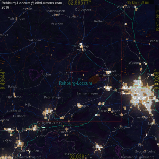
Analysis of Rehburg-Loccum night lights 2016
Square area 10x10 km:
 0%
0%90-99
0%80-89
0%70-79
0%60-69
0.51%50-59
0%40-49
0.13%30-39
0.38%20-29
0%10-19
0%0-9
98.99%Square area 50x50 km:
0.28%90-99
0.42%80-89
0.19%70-79
0.27%60-69
0.46%50-59
0.47%40-49
0.27%30-39
0.44%20-29
0.31%10-19
0.92%0-9
95.98%Clear (daylight) street map image can be seen on geolist.org.
Map coordinates:
52° 53' 44.8" North, 8° 29' 47.2" East
52° 28' 10.3" North, 9° 11' 58.5" East
52° 2' 20.8" North, 9° 54' 9.7" East
Some cities around Rehburg-Loccum sort by population:
• Neustadt am Rübenberge
18 km =11.2 mi,  77°
77°
• Wunstorf
16.8 km =10.4 mi,  107°
107°
• Nienburg
19.7 km =12.2 mi,  4°
4°
• Petershagen
19 km =11.8 mi,  236°
236°
• Stadthagen
16.3 km =10.1 mi,  179°
179°
• Bad Nenndorf
19.1 km =11.9 mi,  140°
140°
• Stolzenau
10.4 km =6.5 mi,  300°
300°
• Steyerberg
16.3 km =10.1 mi,  313°
313°
2849371 (p: 10,894)
Sources (retrieved 2019-11-25):
» Earth at Night: Flat Maps 2012, 2016