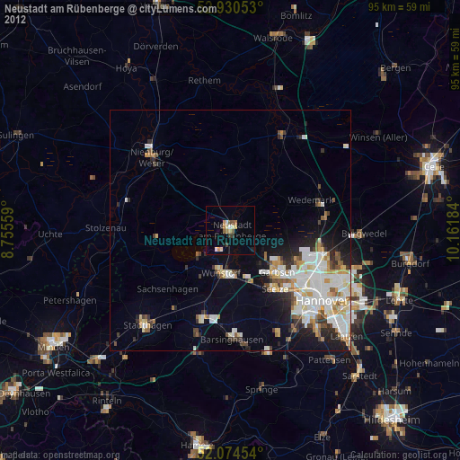
Neustadt am Rübenberge night lights from space
Night Light of Neustadt am Rübenberge (Lower Saxony) from space (Germany) Src. Average luminocity for 10x10km area is 5.7632% and for 50x50km: 10.4241%.
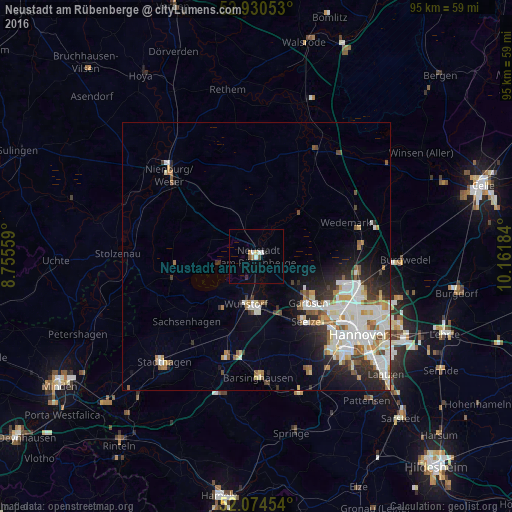
Analysis of Neustadt am Rübenberge night lights 2016
Square area 10x10 km:
 0.66%
0.66%90-99
1.46%80-89
0.53%70-79
0.53%60-69
0.53%50-59
0.93%40-49
0.13%30-39
0%20-29
0.93%10-19
0.13%0-9
94.18%Square area 50x50 km:
2.61%90-99
2.75%80-89
0.85%70-79
0.89%60-69
1.07%50-59
1.22%40-49
0.75%30-39
1.04%20-29
2.4%10-19
3.24%0-9
83.18%Clear (daylight) street map image can be seen on geolist.org.
Map coordinates:
52° 55' 49.9" North, 8° 45' 20.1" East
52° 30' 16.6" North, 9° 27' 31.4" East
52° 4' 28.3" North, 10° 9' 42.6" East
Some cities around Neustadt am Rübenberge sort by population:
• Garbsen
13.5 km =8.4 mi,  138°
138°
• Langenhagen
19.9 km =12.4 mi,  108°
108°
• Wunstorf
9.1 km =5.7 mi,  189°
189°
• Seelze
15.3 km =9.5 mi, 142°
• Rehburg-Loccum
18 km =11.2 mi,  257°
257°
• Bad Nenndorf
19.4 km =12.1 mi,  196°
196°
• Garbsen-Mitte
13.1 km =8.1 mi,  131°
131°
• Auf der Horst
13.6 km =8.5 mi, 134°
2864058 (p: 45,942)
Sources (retrieved 2019-11-25):
» Earth at Night: Flat Maps 2012, 2016