Schwarmstedt night lights from space
Night Light of Schwarmstedt (Lower Saxony) from space (Germany) Src. Average luminocity for 10x10km area is 0.8955% and for 50x50km: 1.8332%.
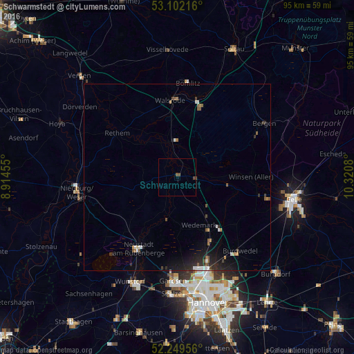
Analysis of Schwarmstedt night lights 2016
Square area 10x10 km:
 0%
0%90-99
0%80-89
0%70-79
0%60-69
0%50-59
0.53%40-49
1.32%30-39
0%20-29
0%10-19
0%0-9
98.15%Square area 50x50 km:
0.25%90-99
0.22%80-89
0.07%70-79
0.11%60-69
0.16%50-59
0.42%40-49
0.26%30-39
0.2%20-29
0.76%10-19
1.51%0-9
96.04%Clear (daylight) street map image can be seen on geolist.org.
Map coordinates:
53° 6' 7.8" North, 8° 54' 52.4" East
52° 40' 40.6" North, 9° 37' 3.6" East
52° 14' 58.4" North, 10° 19' 14.9" East
Some cities around Schwarmstedt sort by population:
• Langenhagen
26.9 km =16.7 mi,  162°
162°
• Neustadt am Rübenberge
22.1 km =13.7 mi,  209°
209°
• Walsrode
20.5 km =12.7 mi,  355°
355°
• Bad Fallingbostel
21.6 km =13.4 mi,  14°
14°
• Winsen
20 km =12.4 mi,  88°
88°
• Hambühren
25.2 km =15.7 mi,  101°
101°
• Wietze
14.9 km =9.3 mi, 102°
• Bomlitz
24.8 km =15.4 mi, 5°
2835220 (p: 5,159)
Sources (retrieved 2019-11-25):
» Earth at Night: Flat Maps 2012, 2016